Pinsot | |
|---|---|
Part of Le Haut-Bréda | |
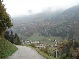 A view of the village of Pinsot | |
Location of Pinsot | |
 Pinsot  Pinsot | |
| Coordinates: 45°21′28″N 6°06′03″E / 45.3578°N 6.1008°E | |
| Country | France |
| Region | Auvergne-Rhône-Alpes |
| Department | Isère |
| Arrondissement | Grenoble |
| Canton | Le Haut-Grésivaudan |
| Commune | Le Haut-Bréda |
| Area 1 | 24 km2 (9 sq mi) |
| Population (2019)[1] | 159 |
| • Density | 6.6/km2 (17/sq mi) |
| Demonym | Pinsotins / Pinsotines |
| Time zone | UTC+01:00 (CET) |
| • Summer (DST) | UTC+02:00 (CEST) |
| Postal code | 38580 |
| Elevation | 551–2,858 m (1,808–9,377 ft) |
| 1 French Land Register data, which excludes lakes, ponds, glaciers > 1 km2 (0.386 sq mi or 247 acres) and river estuaries. | |
Pinsot (French pronunciation: [pɛ̃so] ⓘ) is a former commune in the Isère department in southeastern France. On 1 January 2019, it was merged into the new commune Le Haut-Bréda.[2]
Population
|
|
Sights
- The Iron Route of Pinsot (Le Sentier du Fer de Pinsot) is a forest trail leading visitors to discover the old mining industry of the town. Historic sites such as minors houses, disaffected mines and cinders can be seen.
- Le Cohard is a hamlet which is the starting point for many hiking trails into the Gleyzin mountain in the Belledonne massif.
Born in Pinsot
- Jules David (1848-1923), photographer
See also
References
- ↑ Téléchargement du fichier d'ensemble des populations légales en 2019, INSEE
- ↑ Arrêté préfectoral 18 December 2018 (in French)
Wikimedia Commons has media related to Pinsot.
This article is issued from Wikipedia. The text is licensed under Creative Commons - Attribution - Sharealike. Additional terms may apply for the media files.