Platykampos
Πλατύκαμπος | |
|---|---|
 Platykampos Location within the regional unit 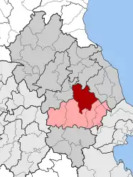 | |
| Coordinates: 39°37′N 22°32′E / 39.617°N 22.533°E | |
| Country | Greece |
| Administrative region | Thessaly |
| Regional unit | Larissa |
| Municipality | Kileler |
| • Municipal unit | 244.7 km2 (94.5 sq mi) |
| Population (2011)[1] | |
| • Municipal unit | 7,896 |
| • Municipal unit density | 32/km2 (84/sq mi) |
| Community | |
| • Population | 1,804 (2011) |
| • Area (km2) | 28.308 |
| Time zone | UTC+2 (EET) |
| • Summer (DST) | UTC+3 (EEST) |
| Vehicle registration | ΡΙ |
Platykampos (Greek: Πλατύκαμπος) is a village and a former municipality in the Larissa regional unit, Thessaly, Greece. Since the 2011 local government reform it is part of the municipality Kileler, of which it is a municipal unit.[2] Population 7,896 (2011). The municipal unit has an area of 244.698 km2.[3]
References
- 1 2 "Απογραφή Πληθυσμού - Κατοικιών 2011. ΜΟΝΙΜΟΣ Πληθυσμός" (in Greek). Hellenic Statistical Authority.
- ↑ "ΦΕΚ B 1292/2010, Kallikratis reform municipalities" (in Greek). Government Gazette.
- ↑ "Population & housing census 2001 (incl. area and average elevation)" (PDF) (in Greek). National Statistical Service of Greece.
This article is issued from Wikipedia. The text is licensed under Creative Commons - Attribution - Sharealike. Additional terms may apply for the media files.