Plummers Point | |
|---|---|
Rural settlement | |
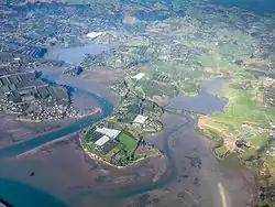 Plummers Point (lower centre) | |
| Coordinates: 37°39′29″S 176°02′49″E / 37.658°S 176.047°E | |
| Country | New Zealand |
| Region | Bay of Plenty |
| Territorial authority | Western Bay of Plenty District |
| Ward | Kaimai Ward |
| Electorates | |
| Government | |
| • Territorial Authority | Western Bay of Plenty District Council |
| • Regional council | Bay of Plenty Regional Council |
| Area | |
| • Total | 0.60 km2 (0.23 sq mi) |
| Population (June 2023)[2] | |
| • Total | 280 |
| • Density | 470/km2 (1,200/sq mi) |
| Postcode(s) | 3172 |
Plummers Point is a rural settlement in the Western Bay of Plenty District and Bay of Plenty Region of New Zealand's North Island. It is on a headland on the southern side of Tauranga Harbour, opposite Motuhoa Island, and between Mangawhai Bay and Te Puna Estuary. The East Coast Main Trunk forms its southern boundary.[3]
Ongarahu Pā is on 12 to 15 metre-high cliffs at the northern end.[4] It is well-preserved and a tourist attraction.[5]
Demographics
Plummers Pointt is described by Statistics New Zealand as a rural settlement, which covers 0.60 km2 (0.23 sq mi)[1] and had an estimated population of 280 as of June 2023,[2] with a population density of 467 people per km2. It is part of the wider Omokoroa Rural statistical area.[6]
| Year | Pop. | ±% p.a. |
|---|---|---|
| 2006 | 132 | — |
| 2013 | 141 | +0.95% |
| 2018 | 153 | +1.65% |
| Source: [7] | ||
Plummers Point had a population of 153 at the 2018 New Zealand census, an increase of 12 people (8.5%) since the 2013 census, and an increase of 21 people (15.9%) since the 2006 census. There were 60 households, comprising 69 males and 84 females, giving a sex ratio of 0.82 males per female. The median age was 51.2 years (compared with 37.4 years nationally), with 21 people (13.7%) aged under 15 years, 24 (15.7%) aged 15 to 29, 69 (45.1%) aged 30 to 64, and 36 (23.5%) aged 65 or older.
Ethnicities were 98.0% European/Pākehā, 5.9% Māori, and 2.0% Pacific peoples. People may identify with more than one ethnicity.
Although some people chose not to answer the census's question about religious affiliation, 49.0% had no religion, 35.3% were Christian and 2.0% had other religions.
Of those at least 15 years old, 30 (22.7%) people had a bachelor's or higher degree, and 15 (11.4%) people had no formal qualifications. The median income was $37,800, compared with $31,800 nationally. 27 people (20.5%) earned over $70,000 compared to 17.2% nationally. The employment status of those at least 15 was that 51 (38.6%) people were employed full-time, and 33 (25.0%) were part-time.[7]
References
- 1 2 "ArcGIS Web Application". statsnz.maps.arcgis.com. Retrieved 1 December 2022.
- 1 2 "Subnational population estimates (RC, SA2), by age and sex, at 30 June 1996-2023 (2023 boundaries)". Statistics New Zealand. Retrieved 25 October 2023. (regional councils); "Subnational population estimates (TA, SA2), by age and sex, at 30 June 1996-2023 (2023 boundaries)". Statistics New Zealand. Retrieved 25 October 2023. (territorial authorities); "Subnational population estimates (urban rural), by age and sex, at 30 June 1996-2023 (2023 boundaries)". Statistics New Zealand. Retrieved 25 October 2023. (urban areas)
- ↑ Harriss, Gavin (August 2022). Te Puna Estuary, Bay of Plenty (Map). NZ Topo Map.
- ↑ Taylor, Tonkin (1 July 2019). "Final - Erosion - Tauranga Harbour Erosion Hazard Assessment–Plummers Point" (PDF). Western Bay of Plenty District Council.
- ↑ "Ongarahu Pa & Huharua Reserve". New Zealand Tourism Guide. Retrieved 1 December 2022.
- ↑ 2018 Census place summary: Omokoroa Rural
- 1 2 "Statistical area 1 dataset for 2018 Census". Statistics New Zealand. March 2020. 7013632.