| Podocarpus National Park | |
|---|---|
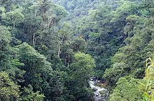
 Trees surrounding the Bombuscaro river | |
 | |
| Location | Ecuador Zamora Chinchipe and Loja |
| Nearest city | Loja, Loja, Ecuador |
| Coordinates | 4°17′0″S 79°0′0″W / 4.28333°S 79.00000°W |
| Area | 1462.8 km2 |
| Established | 1982 |
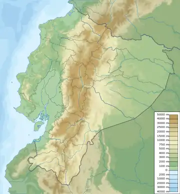
Podocarpus National Park (Spanish: Parque Nacional Podocarpus) is a national park located in the provinces of Zamora Chinchipe and Loja, in the south-east of Ecuador. It was created in 1982.[1]
It covers 1,462.8 square kilometres (564.8 sq mi), from two spurs of the eastern range of the Andes to the basins of the Nangaritza, Numbala, and Loyola rivers. About 85 per cent of the park is in the province of Zamora Chinchipe, and the remainder is in the province of Loja. It is categorized as a megadiverse zone and an area with a high level of endemic species because it is a meeting point between four ecological systems: Northern Andes, Southern Andes, Amazonian, and Pacific.[2] Although considerable knowledge has been gathered about its biodiversity in parts of the area, only a minority of the species inhabiting the park has been discovered so far.[3]
The Podocarpus National Park spans from lower montane rain forests at about 1,000 metres (3,300 ft) elevation, up to high elevation elfin forests at 3,000 metres (9,800 ft). Paramo or subparamo vegetation is found at elevations above 3,000 m (9,800 ft) where a complex of more than 100 lagoons exists, among the best-known being the Lagunas del Compadre.
The park has two main entrances. One is in the Cajanuma Sector, about 8 kilometres (5.0 mi) south of Loja, where elfin forest and paramo habitats at elevations between some 2,900 and 3,500 metres (9,500 and 11,500 ft) can be accessed. The other is in the Bombuscaro Sector, corresponding to the Bombuscaro River, in lower montane forest habitats at elevations from roughly 1,000 metres (3,300 ft) upwards. There are two alternative entrances without park guards. The Romerillos Sector, corresponding to the Jamboé River southeast of the Bombuscaro Sector, is also an entrance for gold miners who work inside the park. Another entrance is at Cerro Toledo, east of the Yangana-Valladolid route in the southwestern part of the park.
Flora
The park contains an exceptionally diverse flora, and has been considered the 'Botanical Garden of America'. Its high and low mountain-forest ecosystems, located in the Nudo de Sabanilla pass, and its very humid mountain and premontane forests in the basin of the Numbala River, have more than 4,000 species of plants including trees that can measure up to 40 metres (130 ft), like the romerillo (Podocarpus glomeratus) which gives its name to the park, and many other valuable species like the Cinchona – the national tree of Ecuador – and a huge variety of orchids.
Among the main species found in the region are chilca (Baccharis spp.), laurel, San Pedro cactus, Physalis peruviana (uvilla), black elder, pumamaqui (Oreopanax sp.), sappanwood, arrayán, cashoco, alder, acacia, sage, guato blanco, cedar, castor oil plant, walnut, yumbingue (Terminalia guyanensis) and canelón (Swartzia littlei).
Fauna
So far, 68 species of mammals have been recorded in the park and its surroundings;[4] four of them are on Ecuador's "Red List" as either endangered or vulnerable:
- Mountain tapir (Tapirus pinchaque)
- Spectacled bear (Tremarctos ornatus)
- Northern pudu (Pudu mephistophiles)
- Jaguar (Panthera onca)
Other notable mammals include:
- Amazonian hog-nosed skunk (Conepatus semistriatus)
- Common grey shrew opossum (Caenolestes fuliginosus)
There are 560 registered species of birds, which accounts for six per cent of all birds registered worldwide and 40 per cent of the birds registered in Ecuador.[2] For this reason it was identified in 1995 by Wedge and Long as one of the important areas for the conservation of neotropic birds.[2]
The area has also been identified as a diversity hotspot of insects such as geometrid moths. So far, 1,266 species of this family have been recorded in the northern part of the park and adjacent montane forests, a number exceeding any other place in the world.[5]
Tourist information
The city of Loja is nearby, approximately 25–90 minutes from the two major entrances of Cajanuma and Bombuscaro. There are three guided trails that take from 15 minutes (Speckled Bear Trail) to 1 hour and 20 minutes (Cloud Forest Trail). There are longer trails for those who prefer to backpack or camp. Visitors can also enter from Vilcabamba and Zamora, which are both located directly next to the national park.
Climate
The rainy season varies throughout the park. In the east the rainy season is March – July, while in the west the rainy season is October – December. The mean temperature at high elevations is 12 °C (54 °F) while in the lower parts of the park it is 18 °C (64 °F).[6]
External links
References
- ↑ "Andes" at EcuadorExplorer.com
- 1 2 3 Guide to Podocarpus National Park
- ↑ Brehm, G.; Homeier, J.; Fiedler, K.; Kottke, I.; Illig, J.; Nöske, N. M.; Werner, F. A.; Breckle, S. W. (2008). "Mountain Rain Forests in Southern Ecuador as a Hotspot of Biodiversity – Limited Knowledge and Diverging Patterns". Gradients in a Tropical Mountain Ecosystem of Ecuador. Ecological Studies. Vol. 198. pp. 15–23. doi:10.1007/978-3-540-73526-7_2. ISBN 978-3-540-73525-0.
- ↑ Liede-Schumann, S.; Breckle, Siegmar-W. (2008). Provisional checklists of flora and fauna of the San Francisco Valley and its surroundings: Reserva Biológica San Francisco, Prov. Zamora-Chinchipe, Southern Ecuador. Bonn, Germany: Society of Tropical Ecology. ISBN 9783980778039. OCLC 228007388.
- ↑ Brehm, Gunnar; Pitkin, Linda M.; Hilt, Nadine; Fiedler, Konrad (2005). "Montane Andean rain forests are a global diversity hotspot of geometrid moths". Journal of Biogeography. 32 (9): 1621–1627. doi:10.1111/j.1365-2699.2005.01304.x.
- ↑ Loja city Tourist information