Poniente Almeriense | |
|---|---|
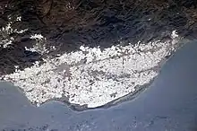
 "Sea of plastic" and the town of El Ejido | |
 | |
| Country | Spain |
| Autonomous community | Andalusia |
| Province | Almería |
| Municipalities | List
|
| Area | |
| • Total | 971 km2 (375 sq mi) |
| Population (2018)[1] | |
| • Total | 259,357 |
| • Density | 270/km2 (690/sq mi) |
| Time zone | UTC+1 (CET) |
| • Summer (DST) | UTC+2 (CEST) |
| Largest municipality | El Ejido |
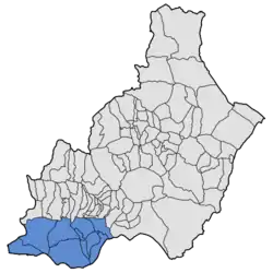
Poniente Almeriense is a comarca in Almería, Spain. It is sometimes also known as the "sea of plastic" (Mar de plástico) due to the numerous greenhouses that cover the area. The comarca contains ten municipalities (the tenth, Balanegra, was created in 2015 from part of Berja municipality) and 259,357 inhabitants[2] in an area of 971 km2. The "sea of plastic" was one of the subjects of We feed the world, a 2005 documentary; and the setting of Spanish crime drama Mar de plástico.
The typical agricultural products of the greenhouses are: cucumbers, watermelons, eggplants, zucchinis, peaches, peppers and tomatoes.[3]
The comarca borders the Alboran Sea to the South, the city of Almería to the east, the Sierra de Gádor to the north, and the municipality of Albuñol (in Granada province) to the west.
Municipalities
The Poniente Almeriense contains the following ten municipalities:
| Municipality | Population 2011[4] | Population 2018[5] |
|---|---|---|
| Adra | 24,375 | 24,859 |
| Balanegra + | - | 2,983 |
| Berja + | 15,155 | 12,381 |
| Dalías | 4,007 | 4,031 |
| El Ejido | 80,839 | 84,710 |
| Enix | 426 | 418 |
| Felix | 663 | 642 |
| La Mojonera | 8,476 | 9,003 |
| Roquetas de Mar | 86,799 | 94,925 |
| Vícar | 23,482 | 25,405 |
| Totals | 244,222 | 259,357 |
Note: + an additional municipality, Balanegra, was created in 2015 from part of Berja municipality.

References
- ↑ Estimate at 1 January 2018: Instituto Nacional de Estadística, Madrid.
- ↑ Estimate at 1 January 2018: Instituto Nacional de Estadística, Madrid.
- ↑ "Greenhouse Farming". my almeria. Retrieved 21 September 2021.
- ↑ Census at 1 November 2011: Instituto Nacional de Estadística, Madrid.
- ↑ Estimate at 1 January 2018: Instituto Nacional de Estadística, Madrid.
External links
- Las Norias de Daza - Google maps
- Greenhouses of the Campo de Dalías, Almería Province, Spain - NASA Earth Observatory
- Southeastern Spain's Greenhouse Landscape: Plastic over Sand-Beds.
36°46′56″N 2°44′35″W / 36.78234°N 2.74315°W