| Main page | Maps |
The Maps and Cartography Portal
A map is a symbolic depiction emphasizing relationships between elements of some space, such as objects, regions, or themes.
Many maps are static, fixed to paper or some other durable medium, while others are dynamic or interactive. Although most commonly used to depict geography, maps may represent any space, real or fictional, without regard to context or scale, such as in brain mapping, DNA mapping, or computer network topology mapping. The space being mapped may be two dimensional, such as the surface of the Earth, three dimensional, such as the interior of the Earth, or even more abstract spaces of any dimension, such as arise in modeling phenomena having many independent variables.
Although the earliest maps known are of the heavens, geographic maps of territory have a very long tradition and exist from ancient times. The word "map" comes from the medieval Latin: Mappa mundi, wherein mappa meant 'napkin' or 'cloth' and mundi 'the world'. Thus, "map" became a shortened term referring to a two-dimensional representation of the surface of the world. (Full article...)
Cartography (/kɑːrˈtɒɡrəfi/; from Ancient Greek: χάρτης chartēs, 'papyrus, sheet of paper, map'; and γράφειν graphein, 'write') is the study and practice of making and using maps. Combining science, aesthetics and technique, cartography builds on the premise that reality (or an imagined reality) can be modeled in ways that communicate spatial information effectively. (Full article...)
Selected article -
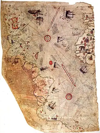
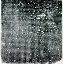
The Piri Reis map is a world map compiled in 1513 by the Ottoman admiral and cartographer Piri Reis. Approximately one third of the map survives, housed in the Topkapı Palace in Istanbul. When rediscovered in 1929, the remaining fragment garnered international attention as it includes a partial copy of an otherwise lost map by Christopher Columbus.
The map is a portolan chart with compass roses and a windrose network for navigation, rather than lines of longitude and latitude. It contains extensive notes primarily in Ottoman Turkish. The depiction of South America is detailed and accurate for its time. Scholars attribute the peculiar arrangement of the Caribbean to a now-lost map from Columbus that depicted Cuba as part of the Asian mainland and Hispaniola according to Marco Polo's description of Japan. The southern coast of the Atlantic Ocean is widely accepted to be a version of Terra Australis. (Full article...)General images -
 The Propaganda Map, a 1529 version of the Padrón Real now held by the Vatican Library. (from History of cartography)
.jpg.webp)
 A chart of an unidentified area (from History of cartography)
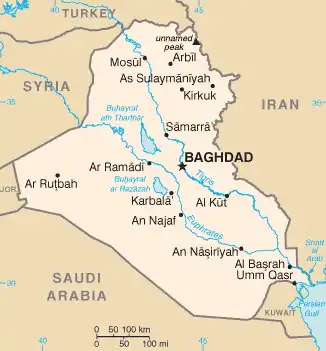 CIA map of Iraq, following typical labeling guidelines to maximize legibility and association (from Cartographic design)
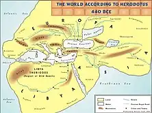 The world according to Herodotus, 440 BC (from History of cartography)
.jpg.webp) Map of the Holy Land, Pietro Vesconte, 1321. Described by Adolf Erik Nordenskiöld as "the first non-Ptolemaic map of a definite country". (from History of cartography)
Map of the Holy Land, Pietro Vesconte, 1321. Described by Adolf Erik Nordenskiöld as "the first non-Ptolemaic map of a definite country". (from History of cartography) Map of Biscayne National Park, Florida, using a variety of point symbols, along with line and area symbols. Note the use of coordinated fill and stroke symbols for the national park area to solve the challenge of a water boundary. (from Cartographic design)
 A map of Sikkim, India using shaded relief and hypsometric tints (a form of isarithm) to visualize terrain (from Cartographic design)
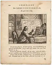 A portrait of a mapmaker looking up intently from his charts and holding a caliper, 1714. (from History of cartography)
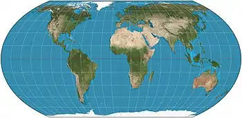 The Equal Earth projection (2018), an increasingly popular equal-area pseudocylindrical projection for world maps (from Cartographic design)
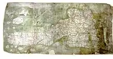 The Gough Map, a road map of 14th-century Britain (from History of cartography)
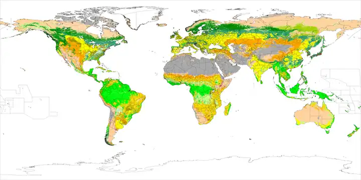 A chorochromatic map of world land cover, using hue, value, and saturation to differentiate nominal values (from Cartographic design)
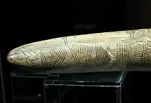 Possibly the oldest surviving map has been engraved on this mammoth tusk, dated to 25,000 BC, found from Pavlov in the Czech Republic. (from History of cartography)
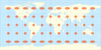
 The Mercator projection with Tissot's indicatrix of deformation. (The distortion increases without limit at higher latitudes) (from Scale (map))
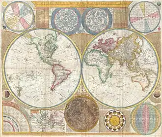 A general map of the world by Samuel Dunn, 1794, containing star chart, map of the Solar System, map of the Moon and other features along with Earth's both hemispheres. (from History of cartography)
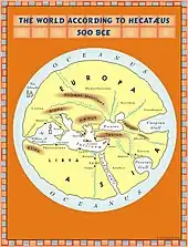 The world according to Hekatæus, 500 BC (from History of cartography)
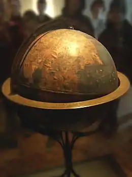 Martin Behaim's Erdapfel (1492) is considered to be the oldest surviving terrestrial globe. (from History of cartography)
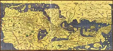 The Tabula Rogeriana, drawn by Muhammad al-Idrisi for Roger II of Sicily in 1154. Note that the north is at the bottom, and so the map appears "upside down" compared to modern cartographic conventions. (from History of cartography)
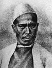 The pundit (explorer) cartographer Nain Singh Rawat (19th century) received a Royal Geographical Society gold medal in 1876. (from History of cartography)
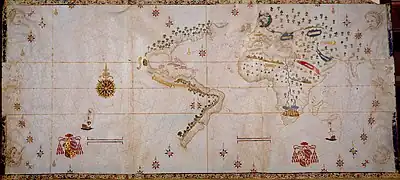 The Salviati Planisphere, a 1526 version of the Padrón Real provided by Charles V to the cardinal who officiated his wedding to Isabella of Portugal. (from History of cartography)
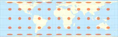 Lambert's normal cylindrical equal-area projection with Tissot's indicatrix of deformation (from Scale (map))
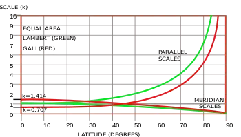 Scale variation for the Lambert (green) and Gall (red) equal area projections. (from Scale (map))
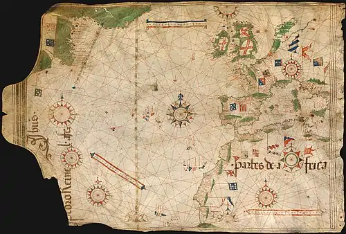 Nautical chart by Pedro Reinel (c. 1504), one of the first based on astronomical observations and to depict a scale of latitudes. (from History of cartography)
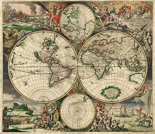
.jpg.webp) Blaeu's world map, originally prepared by Joan Blaeu for his Atlas Maior, published in the first book of the Atlas Van Loon (1664). (from History of cartography)
Blaeu's world map, originally prepared by Joan Blaeu for his Atlas Maior, published in the first book of the Atlas Van Loon (1664). (from History of cartography)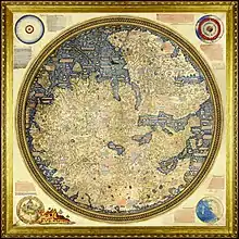 The Fra Mauro map, a medieval European map, was made around 1450 by the Italian monk Fra Mauro. It is a circular world map drawn on parchment and set in a wooden frame, about two meters in diameter. (from History of cartography)
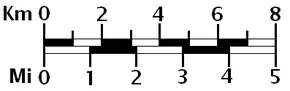 A graphical or bar scale. A map would also usually give its scale numerically ("1:50,000", for instance, means that one cm on the map represents 50,000cm of real space, which is 500 meters) (from Scale (map))
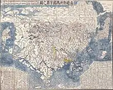 The first Japanese printed map to depict the world, including Europe and America. Printed by woodblock in 1710, composed by the Buddhist monk Rokashi Hotan. (from History of cartography)
 Al-Masudi's world map (10th century) (from History of cartography)
 3D cartography of Washington State, Mount Rainier National Park, Pinnacle Peak trail. (from Cartographic design)
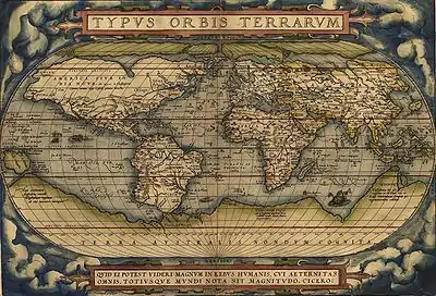
 The Yu Ji Tu, or Map of the Tracks of Yu Gong, carved into stone in 1137, located in the Stele Forest of Xi'an. This 3 ft (0.91 m) squared map features a graduated scale of 100 li for each rectangular grid. China's coastline and river systems are clearly defined and precisely pinpointed on the map. Yu Gong is in reference to the Chinese deity described in the geographical chapter of the Classic of History, dated 5th century BC. (from History of cartography)
.svg.png.webp) Infinitesimal elements on the sphere and a normal cylindrical projection (from Scale (map))
Infinitesimal elements on the sphere and a normal cylindrical projection (from Scale (map))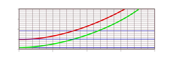 Scale variation near the equator for the tangent (red) and secant (green) Mercator projections. (from Scale (map))
 Illustrated map (from Cartographic design)
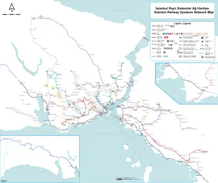 A well-composed transit map of Istanbul, with a high degree of contrast between the symbols, creating a strong visual hierarchy (transit lines are and look most important), figure-ground, and selectivity (the green national rail line can be isolated when necessary). Also note the harmonizing subdued tones of green and blue in the background. (from Cartographic design)
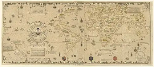
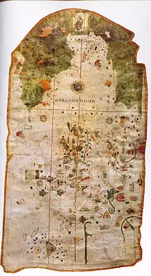 World Map by Juan de la Cosa (1500), the first map showing the Americas. (from History of cartography)
 The Winkel tripel projection with Tissot's indicatrix of deformation (from Scale (map))
 Reconstruction of Pomponius Mela's world map. (from History of cartography)
 Modern version of the Roman Tabula Peutingeriana (5th century). (from History of cartography)
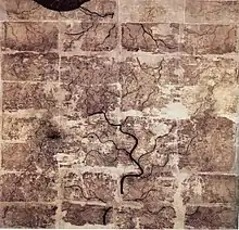 An early Western Han dynasty (202 BC – 9 AD) silk map found in tomb 3 of Mawangdui Han tombs site, depicting the Kingdom of Changsha and Kingdom of Nanyue in southern China (note: the south direction is oriented at the top, north at the bottom). (from History of cartography)
 The 1569 Mercator map of the world. (from History of cartography)
- Surviving fragment of the first World Map of Piri Reis (1513) showing parts of the Americas. (from History of cartography)
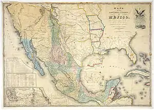 "Mapa de los Estados Unidos de Méjico by John Distrunell, the 1847 map used during the negotiations of the Treaty of Guadalupe Hidalgo ending the Mexican–American War. (from History of cartography)
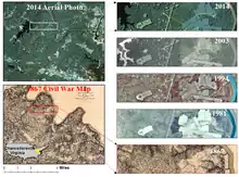 A US civil war hachure paper map made in 1867 by Cartographer Nathaniel Michler vs. modern aerial photos over Chancellorsville, Virginia (from History of cartography)
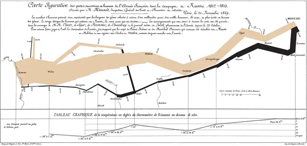 Charles Joseph Minard's map of Napoleon's Russian campaign of 1812 (1844) has been long recognized as a masterwork of cartographic design at a time when such was difficult and rare. (from Cartographic design)
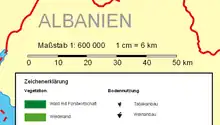 A bar scale with the nominal scale expressed as "1:600 000", meaning 1 cm on the map corresponds to 600,000 cm=6 km on the ground. (from Scale (map))
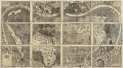 Universalis Cosmographia, the Waldseemüller wall map dated 1507, depicts the Americas, Africa, Europe, Asia, and the Pacific Ocean separating Asia from the Americas, by the Italian Amerigo Vespucci. (from History of cartography)
.jpg.webp) Clay tablet with map of the Babylonian city of Nippur (c. 1400 BC) (from History of cartography)
Clay tablet with map of the Babylonian city of Nippur (c. 1400 BC) (from History of cartography)- Infinitesimal elements on the sphere and a normal cylindrical projection (from Scale (map))
 The equidistant projection with Tissot's indicatrix of deformation (from Scale (map))
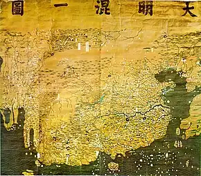 The Da Ming Hun Yi Tu map, dating c. 1390, exists in multicolour format. (from History of cartography)
Selected quote
| “ | Take your map of India, and find, if you can, a more uninviting spot than Calcutta. Placed in the burning plain of Bengal, on the largest delta of the world, amidst a network of sluggish, muddy streams, in the neighbourhood of the jungles and marshes of the Sunderbands, and yet so distant from the open sea as to miss the benefits of the breeze… it unites every condition of a perfectly unhealthy situation. The place is so bad by nature that human efforts could do little to make it worse. | ” |
| — Sir George Trevelyan, Calcutta: Old and New | ||
Related portals
Related WikiProjects
Selected biography -
.jpg.webp)
Hipparchus (/hɪˈpɑːrkəs/; Greek: Ἵππαρχος, Hipparkhos; c. 190 – c. 120 BC) was a Greek astronomer, geographer, and mathematician. He is considered the founder of trigonometry, but is most famous for his incidental discovery of the precession of the equinoxes. Hipparchus was born in Nicaea, Bithynia, and probably died on the island of Rhodes, Greece. He is known to have been a working astronomer between 162 and 127 BC.
Hipparchus is considered the greatest ancient astronomical observer and, by some, the greatest overall astronomer of antiquity. He was the first whose quantitative and accurate models for the motion of the Sun and Moon survive. For this he certainly made use of the observations and perhaps the mathematical techniques accumulated over centuries by the Babylonians and by Meton of Athens (fifth century BC), Timocharis, Aristyllus, Aristarchus of Samos, and Eratosthenes, among others. (Full article...)Selected picture
Did you know
- ... that in 2007, Arthur Gray's £2 Kangaroo and Map stamp sold for a world record price for a single Australian stamp?
- ... that Rose Lee Maphis and her husband Joe Maphis, known as Mr. and Mrs. Country Music, helped develop the Bakersfield sound?
- ... that two My Little Pony: Friendship Is Magic episodes are said to discuss Marxism and Stalinism?
- ... that DeepStateMap.Live, an interactive map of the Russian invasion of Ukraine, received up to 120,000 visitors in 30 minutes during the Battle of Izium in the 2022 Kharkiv counteroffensive?
- ... that the 100 gecs tree was listed as a "place of worship" on Google Maps?
Topics
Map - Atlas - Geography - Topography
Cartography: Cartographers - History of cartography - Ancient world maps - World maps - Compass rose - Generalization - Geographic coordinate system - Geovisualization - Relief depiction - Scale - Terra incognita - Planetary cartography
Map projection: Azimuthal equidistant - "Butterfly" - Dymaxion - Gall–Peters - General Perspective - Goode homolosine - Mercator - Mollweide - Orthographic - Peirce quincuncial - Robinson - Sinusoidal - Stereographic
Maps: Animated mapping - Cartogram - Choropleth map - Estate map - Geologic map - Linguistic map - Nautical chart - Pictorial map - Reversed map - Road atlas - Thematic map - Topographic map - Weather map - Web mapping - World map
Find a map by geographic area or type
Map examples
World

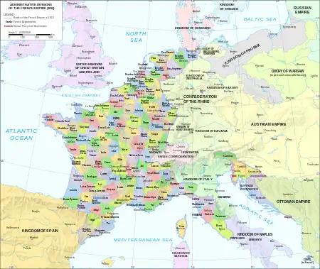
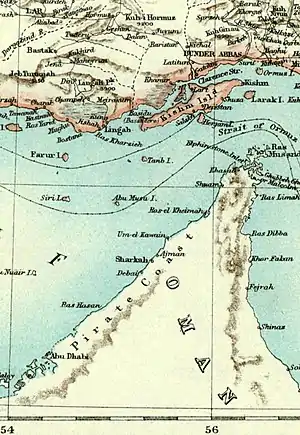
Historical
Thematic
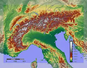
Geographic
Political
Nautical
Categories
Things you can do
|
|
WikiProject: Geography
Here are some Geography related tasks you can do:
|
Atlases and maps of the world at Wikimedia Commons
Associated Wikimedia
The following Wikimedia Foundation sister projects provide more on this subject:
-
 Commons
Free media repository -
 Wikibooks
Free textbooks and manuals -
 Wikidata
Free knowledge base -
 Wikinews
Free-content news -
 Wikiquote
Collection of quotations -
 Wikisource
Free-content library -
 Wikiversity
Free learning tools -
 Wiktionary
Dictionary and thesaurus
-
 List of all portals
 -

-

-

-
-

-

-

-

-

-
 Random portal
 -
 WikiProject Portals