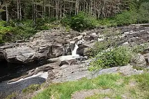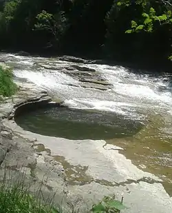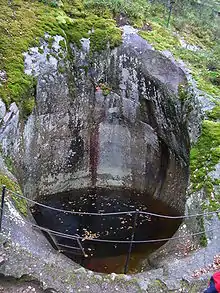
In Earth science, a pothole is a smooth, bowl-shaped or cylindrical hollow, generally deeper than wide, found carved into the rocky bed of a watercourse. Other names used for riverine potholes are pot, (stream) kettle, giant's kettle, evorsion, hollow, rock mill, churn hole, eddy mill, and kolk.[1] Although somewhat related to a pothole in origin, a plunge pool (or plunge basin or waterfall lake) is the deep depression in a stream bed at the base of a waterfall. It is created by the erosional forces of turbulence generated by water falling on rocks at a waterfall's base where the water impacts.[2] Potholes are also sometimes referred to as swirlholes. This word was created to avoid confusion with an English term for a vertical or steeply inclined karstic shaft in limestone. However, given widespread usage of this term for a type of fluvial sculpted bedrock landform, pothole is preferred in usage to swirlhole.[3]

The term pothole is also used to refer to other types of depressions and basins that differ in origin.[1] For example, some authors[4][5] refer to panholes found in the Colorado Plateau also as potholes. Other terms used for panholes are gnamma (Australia), opferkessel (German, roughly “sacrificial basin”), armchair hollows, weathering pans (or pits) and solution pans or solution pits.[6] In another case, the term pothole is used to refer to a shallow depression, generally less than 10-acre (4.0 ha) in area that occurs between dunes or on subdued morainic relief on a prairie, as in Minnesota and the Dakotas, and often contains an intermittent pond or marsh that serves as a nesting place for waterfowl.[1]
Origin
The consensus of geomorphologists and sedimentologists is that fluvial potholes are created by the grinding action of either a stone or stones or coarse sediment (sand, gravel, pebbles, boulders), whirled around and kept in motion by eddies within and force of the stream current in a given spot. Being a spectacular feature of bedrock river channels, they have been and still are studied extensively and considered as a key factor in bedrock channel development and morphology and important factor in the incision of bedrock channels.[3][7][8]
References
- 1 2 3 Neuendorf, K.K.E., J.P. Mehl, Jr., and J.A. Jackson, eds., 2011. Glossary of Geology (5th ed.). Alexandria, Virginia, American Geological Institute. 800 pp. ISBN 0-922152-89-6
- ↑ Marshak, Stephen, 2009. Essentials of Geology, W. W. Norton & Company, 3rd ed. ISBN 978-0393196566
- 1 2 Richardson, K. and Carling, P., 2005. A typology of sculpted forms in open bedrock channels. Special Paper 392. Boulder, Colorado: Geological Society of America. 108 pp. ISBN 0-813723-92-2
- ↑ Chan, M.A., Moser, K., Davis, J.M., Southam, G., Hughes, K. and Graham, T., 2005. Desert potholes: ephemeral aquatic microsystems. Aquatic Geochemistry, 11(3), pp. 279-302.
- ↑ Hughes, Kebbi A., 2012. Bacterial Communities and their Influence on the Formation and Development of Potholes in Sandstone Surfaces of the Semi-Arid Colorado Plateau University of Western Ontario - Electronic Thesis and Dissertation Repository. Paper 543.
- ↑ Twidale, C.R., and Bourne, J.A., 2018. Rock basins (gnammas) revisited. Géomorphologie: Relief, Processus, Environnement, Articles sous presse, Varia, mis en ligne le 08 janvier 2018, consulté le 01 juillet 2018.
- ↑ Das, B.C., 2018. Development of Streambed Potholes and the Role of Grinding Stones. Journal of Environmental Geography. 11 (1–2), 9–16.
- ↑ Whipple, K.X., Hancock, G.S., and Anderson, R.S., 2000. River Incision Into Bedrock: Mechanics And Relative Efficacy Of Plucking, Abrasion And Cavitation. Geological Society Of America Bulletin. 112, 490–503.
