Precious Belt Bridge 宝带桥 | |
|---|---|
 Precious Belt Bridge. | |
| Coordinates | 31°15′32″N 120°38′58.3″E / 31.25889°N 120.649528°E |
| Crosses | Grand Canal and Tantai Lake |
| Locale | Suzhou, Jiangsu Province, China |
| Characteristics | |
| Total length | 317 m (1,040 ft) |
| Width | 4.1 m (13 ft) |
| Location | |
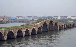
The Precious Belt Bridge (simplified Chinese: 宝带桥; traditional Chinese: 寶帶橋; pinyin: Bǎo dài qiáo) or Baodai Bridge is a stone arch bridge near Suzhou, Jiangsu Province, China. The Precious Belt Bridge is located at the intersection of the Grand Canal and Tantai Lake, about 2.5 kilometer south east of Suzhou.
History
The first construction of the bridge dates back to the year 816 AD, during the mid Tang dynasty.[1] According to written accounts, the bridge derives its name from the local prefect Wang Zhongshu, who in a selfless act had sold his precious belt in order to help finance its construction. Since then, it has been reconstructed several times. The current structure of the Precious Belt Bridge is a Ming dynasty era reconstruction of 1446 AD,[1] during the reign of the Zhengtong Emperor.
John Barrow, while attached to the British Macartney Embassy in 1793, visited the Precious Belt Bridge during the diplomatic mission to China. He accurately described the bridge's length and the central arches being of greater height than the rest.[1]
The bridge was included on the list of national monuments (resolution 5-285) in 2001.
Dimensions
The bridge's span is 317 m (1,040 ft) long and has a width of 4.1 m (13 ft), with a total of 53 arches in its span. The three central arches are enlarged to allow for the passage of – by historical standards – larger river vessels without masts. The average span of each arch is 4.6 m (15 ft).
See also
Notes
References
- Needham, Joseph (1986). Science and Civilization in China: Volume 4, Part 3. Taipei: Caves Books, Ltd.
External links