Pressac | |
|---|---|
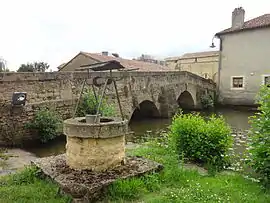 The old bridge, the old well and the Clain river, in Pressac | |
Location of Pressac | |
 Pressac  Pressac | |
| Coordinates: 46°07′00″N 0°34′18″E / 46.1167°N 0.5717°E | |
| Country | France |
| Region | Nouvelle-Aquitaine |
| Department | Vienne |
| Arrondissement | Montmorillon |
| Canton | Civray |
| Government | |
| • Mayor (2020–2026) | Gérard Huguenaud[1] |
| Area 1 | 49.21 km2 (19.00 sq mi) |
| Population | 555 |
| • Density | 11/km2 (29/sq mi) |
| Time zone | UTC+01:00 (CET) |
| • Summer (DST) | UTC+02:00 (CEST) |
| INSEE/Postal code | 86200 /86460 |
| Elevation | 141–216 m (463–709 ft) (avg. 162 m or 531 ft) |
| 1 French Land Register data, which excludes lakes, ponds, glaciers > 1 km2 (0.386 sq mi or 247 acres) and river estuaries. | |
Pressac (French pronunciation: [pʁɛsak]) is a commune in the Vienne department in the Nouvelle-Aquitaine region in western France.
Geography
The Clouère forms the commune's north-eastern border, and the Clain flows northward through the middle of the commune and crosses the village.
See also
References
- ↑ "Répertoire national des élus: les maires". data.gouv.fr, Plateforme ouverte des données publiques françaises (in French). 9 August 2021.
- ↑ "Populations légales 2021". The National Institute of Statistics and Economic Studies. 28 December 2023.
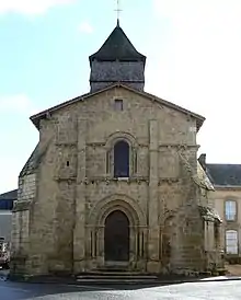
Church in Pressac
Wikimedia Commons has media related to Pressac.
This article is issued from Wikipedia. The text is licensed under Creative Commons - Attribution - Sharealike. Additional terms may apply for the media files.