Highway 19 | ||||
|---|---|---|---|---|
| Ruta 19 | ||||
| Avenida Luis Vigoreaux[1] | ||||
| Route information | ||||
| Maintained by Puerto Rico DTPW | ||||
| Length | 2.0 km[2] (1.2 mi) | |||
| Major junctions | ||||
| South end | ||||
| North end | ||||
| Location | ||||
| Country | United States | |||
| Territory | Puerto Rico | |||
| Municipalities | San Juan, Guaynabo | |||
| Highway system | ||||
| ||||

Puerto Rico Highway 19 (PR-19) is a short highway in Guaynabo.[3] It is the main avenue in San Patricio, Guaynabo. It begins at PR-20 and PR-21 in San Juan and ends an interchange with PR-2 and PR-20 in Guaynabo.[4]
Route description
PR-19 starts at its southern end at an interchange with PR-20 in San Juan. From this terminus, the highway runs through the interchange with PR-20 before intersecting PR-21 and turning northward parallel to the PR-20 freeway on its eastern side. After a short distance, the highway crosses the freeway on Avenida Luis Vigoreaux and then runs northwesterly to cross into Guaynabo. Running due north in Guaynabo, PR-19 passes through two roundabouts and ends at the interchange where PR-20 ends at PR-2.
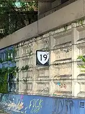 Puerto Rico Highway 19 north in San Juan
 PR-19 south between Guaynabo and San Juan
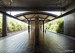 The Martínez Nadal train station in Guaynabo is off PR-19
Major intersections
 Signs for PR-19, PR-20 and PR-21 in Gobernador Piñero, San Juan
.jpg.webp) PR-19 north near PR-17 intersection in Gobernador Piñero, San Juan
PR-19 north near PR-17 intersection in Gobernador Piñero, San Juan.jpg.webp) PR-19 north at the western terminus of PR-17 in Gobernador Piñero, San Juan
PR-19 north at the western terminus of PR-17 in Gobernador Piñero, San Juan
| Municipality | Location | km[2] | mi | Destinations | Notes |
|---|---|---|---|---|---|
| San Juan | Gobernador Piñero | 2.0 | 1.2 | Southern terminus of PR-19; no entrance ramp to PR-20 northbound | |
| 1.6 | 0.99 | ||||
| Guaynabo | Pueblo Viejo | 0.0 | 0.0 | Northern terminus of PR-19; PR-2 eastbound exit and PR-20 southbound entrance | |
| 1.000 mi = 1.609 km; 1.000 km = 0.621 mi | |||||
See also
References
- ↑ "pr.geoview.info". Retrieved 1 June 2019.
- 1 2 Google (28 February 2020). "PR-19" (Map). Google Maps. Google. Retrieved 28 February 2020.
- ↑ National Geographic Maps (2011). Puerto Rico (Map). 1:125,000. Adventure Map (Book 3107). Evergreen, Colorado: National Geographic Maps. ISBN 978-1566955188. OCLC 756511572.
- ↑ Puerto Rico Department of Transportation and Public Works. "Datos de Transito 2000-2009" (in Spanish). Archived from the original on 1 April 2019. Retrieved 28 February 2020.
External links
 Media related to Puerto Rico Highway 19 at Wikimedia Commons
This article is issued from Wikipedia. The text is licensed under Creative Commons - Attribution - Sharealike. Additional terms may apply for the media files.