Highway 693 | ||||
|---|---|---|---|---|
| Ruta 693 | ||||
| Route information | ||||
| Maintained by Puerto Rico DTPW | ||||
| Length | 15.4 km[1] (9.6 mi) | |||
| Existed | 1953[2]–present | |||
| Major junctions | ||||
| South end | ||||
| North end | ||||
| Location | ||||
| Country | United States | |||
| Territory | Puerto Rico | |||
| Municipalities | Dorado, Vega Alta | |||
| Highway system | ||||
| ||||
| ||||


Puerto Rico Highway 693 (PR-693) is a road located between the municipalities of Dorado, Puerto Rico and Vega Alta, passing through downtown Dorado.[3] It begins at its intersection with PR-2 and PR-165 in Río Lajas and ends at PR-690 in Sabana.[4] It is a short divided highway in southern Dorado, which serves as an alternate route for PR-165 west of Río de la Plata.
 Puerto Rico Highway 693 south in downtown Dorado
.jpg.webp) Puerto Rico Highway 693 north in Higuillar, Dorado
Puerto Rico Highway 693 north in Higuillar, Dorado
Major intersections
 View of PR-2 bridge over the La Plata River between Dorado and Toa Baja from PR-693
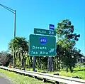
 PR-2 west near PR-165 and PR-693 intersection in La Virgencita
| Municipality | Location | km[1] | mi | Destinations | Notes |
|---|---|---|---|---|---|
| Dorado | Río Lajas | 0.0 | 0.0 | Southern terminus of PR-693 | |
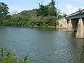
| Maguayo | 0.5 | 0.31 | Puente del Río Nuevo over the Río Nuevo[5] | ||
| 1.4– 1.7 | 0.87– 1.1 | PR-22 exit 24; partial cloverleaf interchange | |||
| 2.6 | 1.6 | ||||
| Higuillar | 3.2 | 2.0 | Seagull intersection | ||
| 5.5 | 3.4 | ||||
| Dorado barrio-pueblo | 6.0 | 3.7 | |||
| 6.4 | 4.0 | One-way street; southbound access via Calle Bailen | |||
| Higuillar | 7.2 | 4.5 | |||
| 7.4– 7.5 | 4.6– 4.7 | ||||
| 8.2 | 5.1 | ||||
| 8.8 | 5.5 | ||||
| Vega Alta | Sabana | 14.1 | 8.8 | ||
| 15.4 | 9.6 | Northern terminus of PR-693 | |||
| 1.000 mi = 1.609 km; 1.000 km = 0.621 mi | |||||
Related route
Highway 6693 | |
|---|---|
| Location | Dorado |
| Length | 1.3 km[6] (0.81 mi) |
Puerto Rico Highway 6693 (PR-6693) is a spur of PR-693 located in Dorado. This road is a bypass located south of the downtown area and goes from PR-693 to PR-696.[3] The entire route is located in Higuillar, Dorado.
 PR-693 south approaching PR-6693 intersection
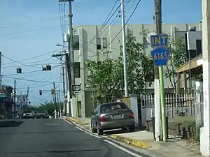 PR-6165 and PR-6693 signs in Dorado barrio-pueblo
| km[6] | mi | Destinations | Notes | ||
|---|---|---|---|---|---|
| 0.0 | 0.0 | Western terminus of PR-6693; access to Hyatt Residence Club Dorado | |||
| 0.6– 0.7 | 0.37– 0.43 | Southern terminus of PR-699 | |||
| 1.3 | 0.81 | Eastern terminus of PR-6693 | |||
| 1.000 mi = 1.609 km; 1.000 km = 0.621 mi | |||||
See also
References
- 1 2 Google (28 February 2020). "PR-693" (Map). Google Maps. Google. Retrieved 28 February 2020.
- ↑ "Dorado, Memoria Núm. 58" (PDF). Puerto Rico Planning Board (in Spanish). 1955. Retrieved 3 August 2020.
- 1 2 National Geographic Maps (2011). Puerto Rico (Map). 1:125,000. Adventure Map (Book 3107). Evergreen, Colorado: National Geographic Maps. ISBN 978-1566955188. OCLC 756511572.
- ↑ Puerto Rico Department of Transportation and Public Works. "Datos de Transito 2000-2009" (in Spanish). pp. 123–124. Archived from the original on 1 April 2019. Retrieved 29 April 2019.
- ↑ Luis F. Pumarada O’Neill (1991). "Los Puentes Históricos de Puerto Rico" (PDF) (in Spanish). p. 49. Retrieved 10 March 2020.
- 1 2 Google (28 February 2020). "PR-6693" (Map). Google Maps. Google. Retrieved 28 February 2020.
External links
Wikimedia Commons has media related to Puerto Rico Highway 693 and Puerto Rico Highway 6693.
This article is issued from Wikipedia. The text is licensed under Creative Commons - Attribution - Sharealike. Additional terms may apply for the media files.