Highway 744 | ||||
|---|---|---|---|---|
| Ruta 744 | ||||
| Carretera Machete | ||||
| Route information | ||||
| Maintained by Puerto Rico DTPW | ||||
| Length | 2.7 km[1] (1.7 mi) | |||
| Major junctions | ||||
| South end | Sector Central Machete in Machete | |||
| North end | ||||
| Location | ||||
| Country | United States | |||
| Territory | Puerto Rico | |||
| Municipalities | Guayama | |||
| Highway system | ||||
| ||||

Puerto Rico Highway 744 (PR-744) is a north–south road located entirely in the municipality of Guayama, Puerto Rico.[2] With a length of 2.7 kilometers (1.7 mi),[1] it begins at its intersection with PR-3 in downtown Guayama[3] and ends at Sector Central Machete in Machete barrio.[4]
Major intersections
The entire route is located in Guayama.
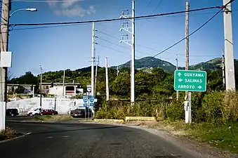 PR-744 approaching PR-54 junction
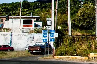 PR-744 at its junction with PR-54
| Location | km[1] | mi | Destinations | Notes | |
|---|---|---|---|---|---|
| Machete | 2.7 | 1.7 | Southern terminus of PR-744 at Sector Central Machete | ||
| Guayama barrio-pueblo | 0.6 | 0.37 | Avenida Pedro Albizu Campos | ||
| 0.0 | 0.0 | Northern terminus of PR-744; access to Guayama Centro, Salinas and Arroyo | |||
| 1.000 mi = 1.609 km; 1.000 km = 0.621 mi | |||||
See also
References
- 1 2 3 Google (14 August 2020). "PR-744" (Map). Google Maps. Google. Retrieved 14 August 2020.
- ↑ National Geographic Maps (2011). Puerto Rico (Map). 1:125,000. Adventure Map (Book 3107). Evergreen, Colorado: National Geographic Maps. ISBN 978-1566955188. OCLC 756511572.
- ↑ "Tránsito Promedio Diario (AADT)". Transit Data (Datos de Tránsito) (in Spanish). Puerto Rico Department of Transportation and Public Works. p. 127. Archived from the original on 1 April 2019. Retrieved 14 August 2020.
- ↑ "PR-744, Guayama, Puerto Rico". geoview.info. Retrieved 14 August 2020.
External links
 Media related to Puerto Rico Highway 744 at Wikimedia Commons
This article is issued from Wikipedia. The text is licensed under Creative Commons - Attribution - Sharealike. Additional terms may apply for the media files.