| Pwalugu Multipurpose Dam | |
|---|---|
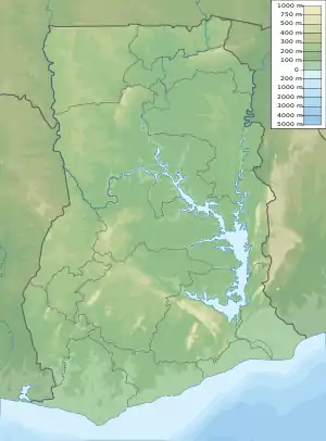
 Map of Ghana showing the location of Pwalugu Multipurpose Dam | |
| Country | Ghana |
| Location | Pwalugu Bridge, White Volta, North East Region, Ghana |
| Coordinates | 10°35′08″N 00°50′30″W / 10.58556°N 0.84167°W |
| Purpose | Drinking, Irrigation & Power |
| Status | Proposed |
| Construction began | April 2020 Expected |
| Opening date | H2: 2024 Estimate |
| Construction cost | US$993 million |
| Owner(s) | Government of Ghana |
| Operator(s) | Volta River Authority |
| Dam and spillways | |
| Impounds | White Volta River |
| Height | 165 metres (541 ft) |
| Reservoir | |
| Surface area | 350 square kilometres (86,000 acres) |
| Normal elevation | 1,400 m (4,600 ft) |
| Commission date | 2026 (expected) |
| Turbines | 2 x 30 MW |
| Installed capacity | 60 MW (80,000 hp) |
The Pwalugu Multipurpose Dam is a planned dam across the White Volta River, in Ghana. The dam will create a reservoir with surface area measuring 350 square kilometres (135 sq mi). The reservoir is expected to provide irrigation water to an estimated 25,000 hectares (62,000 acres) of agricultural land. It will also supply drinking water to populations living downstream of the infrastructure. In addition, the dam will host the Pwalugu Hydroelectric Power Station, with generating capacity of 60 MW (80,000 hp).[1]
Location
The power station would be on the White Volta River, along the Tamale–Bolgatanga Road, at the border of the Upper East Region and the North East Region.[2]
The dam is approximately 24 kilometres (15 mi), by road, southeast of the town of Bolgatanga, on the road to Tamale.[3]
This is approximately 139 kilometres (86 mi) by road, north of Tamale, the nearest large city.[4]
Overview
The dam at this location has been in the country's plans as far back as the 1990s. In 2013, with financial help from the French Development Agency (ADF), and technical assistance from the World Bank, an Environmental and Social Impact Assessment (ESIA) and feasibility study for the construction of a multi-purpose dam and irrigation scheme, were carried out for this site.[2]
In April 2021 the Ghanaian ministerial cabinet approved the project. There had been hesitation to approve the developmental infrastructure project due to the high construction bill, budgeted at US$993 million.[5][6]
It is reported that the 60 megawatts of hydroelectricity generated here will be complemented by a 50 megawatt solar park to be constructed at Kurugu, in East Mamprusi Municipal District, in the North East Region. When completed this combined hydroelectricity/solar power complex will be the first of its kind in Ghana.[5]
Funding
The renewable energy infrastructure project is being developed by the government of Ghana. Partial funding for the early statges was received from the Agence française de développement and the World Bank Group.[2]
Other considerations
In March 2020, it was reported that the engineering, procurement and construction (EPC) contract had been awarded to PowerChina, with a 50 months construction period. Completion is therefore expected in the second half of 2024.[5]
See also
References
- ↑ Jean Marie Takouleu (17 October 2019). "Ghana: Sinohydro to launch work on Pwalugu Multipurpose Dam in November". Afrik21.africa. Paris, France. Retrieved 31 August 2021.
- 1 2 3 Volta River Authority (26 February 2020). "Pwalugu Multipurpose Dam Project". Volta River Authority. Accra, Ghana. Retrieved 31 August 2021.
- ↑ Google (31 August 2021). "Road Distance Between Bolgatanga, Ghana And Pwalugu Multipurpose Dam" (Map). Google Maps. Google. Retrieved 31 August 2021.
- ↑ Google (31 August 2021). "Road Distance Between Tamale, Ghana And Pwalugu Multipurpose Dam" (Map). Google Maps. Google. Retrieved 31 August 2021.
- 1 2 3 Jean Marie Takouleu (3 March 2020). "Ghana: Construction of the Pwalugu multipurpose dam will start in April 2020". Afrik21.africa. Paris, France. Retrieved 31 August 2021.
- ↑ Alhaji (15 August 2021). "Construction of Pwalugu multipurpose dam in Ghana to start in April 2020". Construction Review Online. Nairobi, Kenya. Retrieved 31 August 2021.