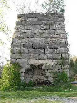
Quarry Limekiln | |
 | |
 Location in Tennessee  Location in United States | |
| Location | TN 49, approx 0.25 mi. E of Denmark Rd., Erin, Tennessee |
|---|---|
| Coordinates | 36°19′01″N 87°42′44″W / 36.31694°N 87.71222°W |
| Area | 2.2 acres (0.89 ha) |
| Built | c.1873 |
| MPS | Lime Industry of Houston County, Tennessee |
| NRHP reference No. | 04001229[1] |
| Added to NRHP | November 10, 2004 |
The Quarry Limekiln, near Erin, Tennessee, dating from around 1873,[2] was listed on the National Register of Historic Places in 2004.[1]
It is a "single masonry 'perpetual-burning' limekiln", built of limestone blocks on its exterior and with brick in its interior. It is about 22 feet (6.7 m) tall, on a base about 18 by 20.5 feet (5.5 m × 6.2 m) in size, tapering up to a top that is about 13 by 17 feet (4.0 m × 5.2 m).
It was deemed significant for its association with the lime industry in the history of Houston County (where the lime industry was the most significant industry) and the Middle Tennessee region.[2]
It is located on State Route 49, approximately 0.25 miles east of Denmark Rd.[1]
References
- 1 2 3 "National Register Information System". National Register of Historic Places. National Park Service. November 2, 2013.
- 1 2 Jeffrey Plunkett; Michelle Marushia; Dr. Wayne Bischoff (December 2003). "National Register of Historic Places Registration: Quarry Limekiln / Arlington Lime Company; E.W. Rauscher Lime works; Erin Lime and Stone Company; Metcalf Stone Company". National Park Service. Retrieved April 25, 2019. With accompanying eight photos
This article is issued from Wikipedia. The text is licensed under Creative Commons - Attribution - Sharealike. Additional terms may apply for the media files.