| Quebec Run Tributary to Big Sandy Creek | |
|---|---|
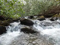 Waterfall along Quebec Run | |
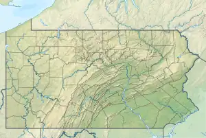 Location of Quebec Run mouth  Quebec Run (the United States) | |
| Location | |
| Country | United States |
| State | Pennsylvania |
| County | Fayette |
| Physical characteristics | |
| Source | Brownfield Hollow divide |
| • location | about 2 miles northeast of Wymps Gap, Pennsylvania[1] |
| • coordinates | 39°45′51″N 079°42′25″W / 39.76417°N 79.70694°W[2] |
| • elevation | 2,240 ft (680 m)[1] |
| Mouth | Big Sandy Creek |
• location | about 4 miles southwest of Elliottsville, Pennsylvania[3] |
• coordinates | 39°44′12″N 079°39′35″W / 39.73667°N 79.65972°W[2] |
• elevation | 1,550 ft (470 m)[3] |
| Length | 3.74 mi (6.02 km)[4] |
| Basin size | 14.33 square miles (37.1 km2)[5] |
| Discharge | |
| • location | Big Sandy Creek |
| • average | 31.80 cu ft/s (0.900 m3/s) at mouth with Big Sandy Creek[5] |
| Basin features | |
| Progression | east and southeast[4] |
| River system | Monongahela River |
| Tributaries | |
| • left | Mill Run |
| • right | unnamed tributaries |
| Bridges | none |
Quebec Run is a 3.74 mi (6.02 km) long 3rd order tributary to Big Sandy Creek in Fayette County, Pennsylvania. This is the only stream of this name in the United States.[2]
Variant names
According to the Geographic Names Information System, it has also been known historically as:[2]
- Mill Run
Course
Quebec Run rises about 2 miles northeast of Wymps Gap, Pennsylvania,[1] and then flows east and southeast to join Big Sandy Creek about 4 miles southwest of Elliottsville.[3]
Watershed
Quebec Run drains 14.33 square miles (37.1 km2) of area, receives about 50.9 in/year of precipitation, has a wetness index of 320.85, and is about 94% forested.[5]
See also
References
- 1 2 3 "Get Maps". USGS Topoview. US Geological Survey. Retrieved 28 November 2020.
- 1 2 3 4 "GNIS Detail - Quebec Run". geonames.usgs.gov. US Geological Survey. Retrieved 28 November 2020.
- 1 2 3 "Get Maps". USGS Topoview. US Geological Survey. Retrieved 28 November 2020.
- 1 2 "ArcGIS Web Application". epa.maps.arcgis.com. US EPA. Retrieved 28 November 2020.
- 1 2 3 "Quebec Run Watershed Report". US EPA Geoviewer. US EPA. Retrieved 28 November 2020.
This article is issued from Wikipedia. The text is licensed under Creative Commons - Attribution - Sharealike. Additional terms may apply for the media files.