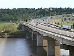
Quesnell Bridge | |
|---|---|
 Quesnell Bridge looking south | |
| Coordinates | 53°30′24″N 113°34′00.5″W / 53.50667°N 113.566806°W |
| Carries | Motor vehicles, pedestrians |
| Crosses | North Saskatchewan River |
| Locale | Edmonton, Alberta, Canada |
| Maintained by | City of Edmonton |
| Characteristics | |
| Total length | 319.8 m (1,049 ft)[1] |
| History | |
| Opened | 1968 |
| Statistics | |
| Daily traffic | 120,300 (2019) |
| Location | |
The Quesnell Bridge is a girder bridge that spans the North Saskatchewan River in Edmonton, Alberta, Canada. It is part of Edmonton's southern freeway, Whitemud Drive. An average of 120,000 cars pass over the bridge every day.[2]
Construction
In 2008, the city announced a project to widen the bridge, Whitemud Drive, and Fox Drive, adding capacity projected to be sufficient until 2058. It was completed in September 2011. In August 2010 during excavation for a sewer-pipeline line several fossils were unearthed about 27 m (89 ft) below ground level. They were believed to be fossils from two extinct genera, Edmontosaurus and Albertosaurus.[3][4]
Quesnell Bridge connects the communities of Brookside/Brander Gardens on the south end to Quesnell Heights/Laurier Heights on the north end.
See also
References
- ↑ Quesnell Bridge at Structurae
- ↑ "Quesnell Bridge & Whitemud Drive Widening & Rehabilitation Project". City of Edmonton. Retrieved August 17, 2009.
- ↑ Sunger, Sonia (August 23, 2010). "Local dinosaur find generates a flurry of excitement". CTV Edmonton. Retrieved August 26, 2010.
- ↑ Landry, Frank (August 23, 2010). "Edmonton crews find dinosaur bones deep under the city". Toronto Sun. Retrieved August 26, 2010.