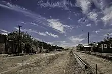
Quillagua is an oasis in the Tocopilla Province, in the Antofagasta Region of northern Chile. It is a part of the commune of María Elena. The Loa River is crossed by the Pan-American Highway in this area. According to the Dirección Meteorológica de Chile, Quillagua is drier than Arica and thus it is the driest place on Earth. This is also recognized by Guinness World Records.[1]
| Climate data for Quillagua (1971-2000) | |||||||||||||
|---|---|---|---|---|---|---|---|---|---|---|---|---|---|
| Month | Jan | Feb | Mar | Apr | May | Jun | Jul | Aug | Sep | Oct | Nov | Dec | Year |
| Mean daily maximum °C (°F) | 26.9 (80.4) |
26.7 (80.1) |
25.3 (77.5) |
23.4 (74.1) |
21.1 (70.0) |
19.1 (66.4) |
18.8 (65.8) |
19.3 (66.7) |
21.4 (70.5) |
22.5 (72.5) |
24.0 (75.2) |
26.0 (78.8) |
22.9 (73.2) |
| Daily mean °C (°F) | 21.9 (71.4) |
21.7 (71.1) |
20.3 (68.5) |
18.4 (65.1) |
16.2 (61.2) |
14.3 (57.7) |
14.0 (57.2) |
14.5 (58.1) |
16.5 (61.7) |
17.6 (63.7) |
19.0 (66.2) |
20.5 (68.9) |
17.9 (64.2) |
| Mean daily minimum °C (°F) | 16.9 (62.4) |
16.8 (62.2) |
15.4 (59.7) |
13.4 (56.1) |
11.3 (52.3) |
9.5 (49.1) |
9.3 (48.7) |
9.8 (49.6) |
11.6 (52.9) |
12.7 (54.9) |
14.0 (57.2) |
15.0 (59.0) |
13.0 (55.3) |
| Average rainfall mm (inches) | 0.05 (0.00) |
0.0 (0.0) |
0.0 (0.0) |
0.0 (0.0) |
0.0 (0.0) |
0.0 (0.0) |
0.0 (0.0) |
0.0 (0.0) |
0.0 (0.0) |
0.0 (0.0) |
0.0 (0.0) |
0.0 (0.0) |
0.05 (0) |
| Source 1: Quillagua climate information [2] | |||||||||||||
| Source 2: Rainfall data[3] | |||||||||||||
See also
References
- ↑ Middleton, Nick (2003). Going to Extremes. London: Pan Books. p. 129. ISBN 978-0-330-49384-0.
- ↑ "Quillagua climate: Average Temperature, weather by month, Quillagua weather averages - Climate-Data.org". en.climate-data.org. Retrieved 2021-12-26.
- ↑ "Weather Extremes : Time to Update World's Driest and Wettest Locations? | Weather Underground". Archived from the original on 2013-03-29. Retrieved 2013-06-10.
21°39′36″S 69°32′06″W / 21.66000°S 69.53500°W
This article is issued from Wikipedia. The text is licensed under Creative Commons - Attribution - Sharealike. Additional terms may apply for the media files.