Rákóczifalva | |
|---|---|
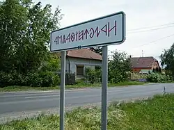 City limit sign - traditional Hungarian letters. | |
 Flag  Coat of arms | |
 Rákóczifalva Location of Rákóczifalva | |
| Coordinates: 47°5′35″N 20°13′44″E / 47.09306°N 20.22889°E | |
| Country | |
| County | Jász-Nagykun-Szolnok |
| District | Szolnok |
| Area | |
| • Total | 35.94 km2 (13.88 sq mi) |
| Population (2015) | |
| • Total | 5,307[1] |
| • Density | 147.6/km2 (382/sq mi) |
| Time zone | UTC+1 (CET) |
| • Summer (DST) | UTC+2 (CEST) |
| Postal code | 5085 |
| Area code | (+36) 56 |
| Website | www |
Rákóczifalva is a town in Jász-Nagykun-Szolnok county, in the Northern Great Plain region of central Hungary.
Geography
It covers an area of 35.94 km2 (14 sq mi) and has a population of 5,307 people (2015).[1]
International relations
Rákóczifalva is twinned with:[2]
 Wierzchosławice, Poland
References
- 1 2 Gazetteer of Hungary, 1st January 2015. Hungarian Central Statistical Office. 3 September 2015
- ↑ Rákóczifalva twinning
External links
Wikimedia Commons has media related to Rákóczifalva.
- Official website in Hungarian, English and German
| City with county rights (1) |
| |
|---|---|---|
| Towns (4) | ||
| Villages (13) |
| |
| City with county rights |
|   |
|---|---|---|
| Towns | ||
| Large villages | ||
| Villages |
| |
| Other topics |
| |
This article is issued from Wikipedia. The text is licensed under Creative Commons - Attribution - Sharealike. Additional terms may apply for the media files.