| Río Rosario | |
|---|---|
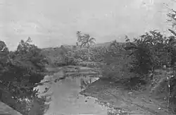 Río Rosario in 1898 | |
| Location | |
| Commonwealth | Puerto Rico |
| Municipality | Hormigueros |
| Physical characteristics | |
| Source | |
| • coordinates | 18°07′46″N 67°08′00″W / 18.1294025°N 67.1332351°W[1] |
| • elevation | 23 ft. |
The Río Rosario is a river of Maricao, Hormigueros, San Germán and Mayagüez in Puerto Rico.[2]
Skirmishes were fought here during the Spanish-American War.
See also
- Maricao Fish Hatchery: located along the river in Maricao, Puerto Rico
- Torréns Bridge: crosses the river in Hormigueros, Puerto Rico
- List of rivers of Puerto Rico
References
- ↑ U.S. Geological Survey Geographic Names Information System: Río Rosario
- ↑ Luis Santiago-Rivera. Low-Flow Characteristics at Selected Sites on Streams in Southern and Western Puerto Rico Water-Resources Investigations Report 95-4147 (1996) (PDF) (Report). U.S. Department of the Interior. p. 35. Retrieved February 18, 2019.
External links
Wikisource has original text related to this article:
This article is issued from Wikipedia. The text is licensed under Creative Commons - Attribution - Sharealike. Additional terms may apply for the media files.