| Rabiosa | |
|---|---|
 The Rabiosa | |
| Location | |
| Location | Canton of Grisons, Switzerland |
| Reference no. | CH: 321 |
| Physical characteristics | |
| Source | |
| • location | Am Fulhorn |
| • coordinates | 46°46′14″N 9°30′23″E / 46.77056°N 9.50639°E |
| Mouth | |
• location | Near Meiersboden into the Plessur |
• coordinates | 46°50′06″N 9°32′46″E / 46.834972°N 9.546028°E |
| Length | 7.9 km [1] |
| Basin size | 52.6 km² [2] |
| Basin features | |
| Progression | Plessur→ Rhine→ North Sea |
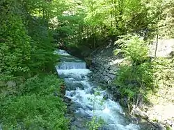
The Rabiosa, also called the Rabiusa[3] or, on in the municipality of Malix, the Landwasser (Alemannic),[4] is a 7.9-kilometre-long, left-hand tributary of the Plessur in the Swiss Canton of Grisons.
References
- ↑ Länge bei hadesdaten.unibe.ch.
- ↑ Geoserver der Schweizer Bundesverwaltung.
- ↑ Charles Knapp, Maurice Borel, Victor Attinger, Heinrich Brunner, Société neuchâteloise de géographie (publisher): Geographisches Lexikon der Schweiz. Vol. 4: Plessur – Schweiz. Verlag Gebrüder Attinger, Neuenburg 1906, p. 62, key word Rabiusa or Rabiosa (scan of the Lexicon page).
- ↑ Schweizerisches Idiotikon Vol. XVI Col. 1820, article Land-Wasser as well as the relevant National Maps of Switzerland.
External links
Wikimedia Commons has media related to Rabiosa.
This article is issued from Wikipedia. The text is licensed under Creative Commons - Attribution - Sharealike. Additional terms may apply for the media files.