Rajdharpur
রাজধরপুর | |
|---|---|
Village | |
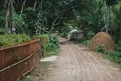
 Street that connects Alikhapara and Boroichara, two out of seven neighbours inside Rajdharpur village. | |
 Rajdharpur Location in Bangladesh | |
| Coordinates: 23°43′22″N 89°34′40″E / 23.7227511°N 89.5776691°E | |
| Country | |
| Division | Dhaka |
| District | Rajbari |
| Upazila | Baliakandi |
| Time zone | UTC+6 (Bangladesh Time) |
| Aerial postal code | 7730 |
Rajdharpur (Bengali: রাজধরপুর) is a village in Rajbari District, Bangladesh, part of Baliakandi Upazila and Islampur Union.[1][2]
Education
- Rajdharpur Madhyamik Bidyalay
- Rajdharpur Government Primary School
- Rajdharpur Kindergarten
References
- ↑ Tipu, Badrul Alam (2012). "Baliakandi Upazila". In Islam, Sirajul; Jamal, Ahmed A. (eds.). Banglapedia: National Encyclopedia of Bangladesh (Second ed.). Asiatic Society of Bangladesh.
- ↑ "NGA GeoNames Database". National Geospatial-Intelligence Agency. Retrieved 9 July 2023.
- Bangladesh Population Census- 2001, Community Series; District: Rajbari | November 2006 | Bangladesh Bureau of Statistics, Planning Division, Ministry of Planning, Government of the People's Republic of Bangladesh.
- Bangladesh Development Acceleration Organization, (BDAO)
This article is issued from Wikipedia. The text is licensed under Creative Commons - Attribution - Sharealike. Additional terms may apply for the media files.