| Rapid Creek Tributary to Cheyenne River | |
|---|---|
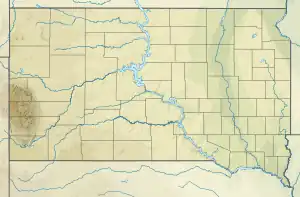
.JPG.webp) The creek in Rapid City's Founders Park | |
 Location of Rapid Creek mouth  Rapid Creek (South Dakota) (the United States) | |
| Location | |
| Country | United States |
| State | South Dakota |
| County | Pennington |
| City | Rapid City |
| Physical characteristics | |
| Source | confluence of North Fork and South Fork of Rapid Creek |
| • location | about 2 miles east-southeast of Hausle Ranch, South Dakota |
| • coordinates | 44°07′51.93″N 103°44′9.71″W / 44.1310917°N 103.7360306°W[1] |
| • elevation | 5,364 ft (1,635 m)[1] |
| Mouth | Cheyenne River |
• location | about 8 miles southeast of Farmingdale, South Dakota |
• coordinates | 43°54′10.96″N 102°37′57.62″W / 43.9030444°N 102.6326722°W[1] |
• elevation | 2,441 ft (744 m)[1] |
| Length | 117.89 mi (189.73 km)[2] |
| Basin size | 715.18 square miles (1,852.3 km2)[3] |
| Discharge | |
| • location | Cheyenne River |
| • average | 93.07 cu ft/s (2.635 m3/s) at mouth with Cheyenne River[3] |
| Basin features | |
| Progression | Cheyenne River → Missouri River → Mississippi |
| River system | Cheyenne |
| Tributaries | |
| • left | North Fork Rapid Creek, Irish Gulch, Moonshine Gulch, Silver Creek, Blind Gulch, Benner Gulch, Minnesota Gulch, Gimlet Creek, Fall Draw, Spurgeon Gulch, Post Draw, Goose Pasture Draw, Gorman Gulch, Sunnyside Gulch, Boarding House Gulch, Deer Creek, Irishman Gulch |
| • right | South Fork Rapid Creek, Smith Gulch, Poverty Gulch, Bearcat Gulch, Cluder Gulch, Castle Creek, Slate Creek, Stewart Gulch, Nugget Gulch, Empress Gulch, Magpie Gulch, Bear Gulch, Custer Gulch, McCurdy Gulch, Tamarack Gulch, Powerhouse Gulch, Prairie Creek, Victoria Creek, Dry Creek, Lindsey Draw, |
| Waterbodies | Pactula Reservoir, Canyon Lake |
Rapid Creek is a tributary of the Cheyenne River, approximately 86 mi (138 km) long, in South Dakota in the United States. The creek's name comes from the Sioux Indians of the area, for the many rapids in the stream.[4]
Course
It rises in southwestern South Dakota, in the Black Hills National Forest in the Black Hills in Pennington County. It flows east, is joined by Castle Creek, past Silver City and through the Pactola Reservoir. Emerging from the Black Hills, it flows through Rapid City, past Farmingdale, and joins the Cheyenne River approximately 13 mi (21 km) southwest of Wasta.
1972 flood
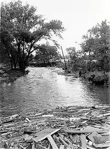
The Rapid Creek is most noted for the Black Hills flood of 1972, in which 238 people perished in Rapid City and in the Black Hills.[5] Since the flood, a flood plain has been established throughout the city making development along the banks inconsiderable.
See also
References
- 1 2 3 4 "Geographic Names Information System". edits.nationalmap.gov. US Geological Survey. Retrieved 4 November 2022.
- ↑ "ArcGIS Web Application". epa.maps.arcgis.com. US EPA. Retrieved November 4, 2022.
- 1 2 "Rapid Creek Watershed Report". watersgeo.epa.gov. US EPA. Retrieved 4 November 2022.
- ↑ Federal Writers' Project (1940). South Dakota place-names, v.1-3. University of South Dakota. p. 52.
- ↑ "The 1972 Black Hills-Rapid City Flood Revisited". United States Geological Survey. Retrieved 2007-10-15.
External links
- U.S. Geological Survey Geographic Names Information System: Rapid Creek
- "Photos of the aftermath of the 1972 flood". U.S. Geological Survey. Retrieved 2012-09-23.