Redland | |
|---|---|
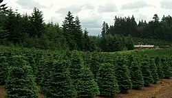
 Christmas tree farm near Redland | |
 Redland Location within the state of Oregon  Redland Redland (the United States) | |
| Coordinates: 45°20′36″N 122°29′34″W / 45.34333°N 122.49278°W | |
| Country | United States |
| State | Oregon |
| County | Clackamas |
| Elevation | 348 ft (106 m) |
| Time zone | UTC-8 (Pacific (PST)) |
| • Summer (DST) | UTC-7 (PDT) |
| ZIP code | 97045 |
| Area code(s) | 503 and 971 |
| GNIS feature ID | 1125911[1] |
Redland is an unincorporated community located in Clackamas County, Oregon, United States. It is located six miles (9.7 km) east of Oregon City and four miles (6.4 km) south of Carver.
The community was named for the color of the soil there.[2]
Redland post office was established in 1892 and closed in 1903.[2]
References
- 1 2 U.S. Geological Survey Geographic Names Information System: Redland, Oregon
- 1 2 McArthur, Lewis A.; Lewis L. McArthur (2003) [1928]. Oregon Geographic Names (7th ed.). Portland, Oregon: Oregon Historical Society Press. p. 802. ISBN 0-87595-277-1.
This article is issued from Wikipedia. The text is licensed under Creative Commons - Attribution - Sharealike. Additional terms may apply for the media files.
