| Departments of the Republic of the Congo Départements de la République du Congo (French) | |
|---|---|
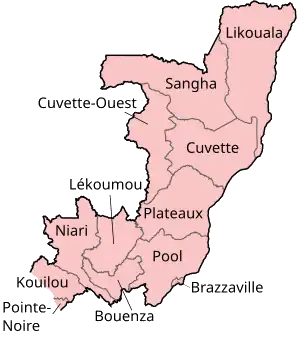
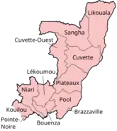
 A clickable map of the Republic of the Congo exhibiting its twelve departments. | |
| Category | Unitary State |
| Location | Republic of the Congo |
| Number | 12 Departments |
| Populations | 72,999 (Cuvette-Ouest) – 1,373,382 (Brazzaville) |
| Areas | 1,140 km2 (442 sq mi) (Pointe-Noire) – 66,000 km2 (25,500 sq mi) (Likouala) |
| Government |
|
| Subdivisions | |
 |
|---|
|
|
The Republic of the Congo is divided into twelve departments (départements, singular département). These departments replaced former regions (régions, singular région) in 2002:[1]
These regions are subdivided into 86 districts and 7 communes; which are further subdivided into urban communities (communautés urbaines) and rural communities (communautés rurales); which are further subdivided into quarters or neighborhoods (quartiers) and villages.
| Department | Capital | Population (2007 census) |
Area (km2) [2] |
Population density
(per km2in 2007) |
Zone |
|---|---|---|---|---|---|
| Kouilou | Hinda | 91,955 | 13,650 | 6.7 | South |
| Niari | Dolisie | 231,271 | 25,942 | 8.9 | South |
| Lékoumou | Sibiti | 96,393 | 20,950 | 4.6 | South |
| Bouenza | Madingou | 309,073 | 12,265 | 25.2 | South |
| Pool | Kinkala | 236,595 | 33,955 | 7 | South |
| Plateaux | Djambala | 174,591 | 38,400 | 4.5 | North |
| Cuvette | Owando | 156,044 | 48,250 | 3.2 | North |
| Cuvette-Ouest | Ewo | 72,999 | 26,600 | 2.7 | North |
| Sangha | Ouesso | 85,738 | 55,800 | 1.5 | North |
| Likouala | Impfondo | 154,155 | 66,044 | 2.3 | North |
| Brazzaville | 1,373,382 | 100 | 13,733.8 | South | |
| Pointe-Noire | 715,335 | 44 | 16,257.6 | South | |
See also
References
- ↑ "Statoid site page on the Congo with additional sources listed". Statoids.com. Retrieved 2012-04-22.
- ↑ Republic of Congo at GeoHive Archived 2012-05-22 at the Wayback Machine
External links
This article is issued from Wikipedia. The text is licensed under Creative Commons - Attribution - Sharealike. Additional terms may apply for the media files.
