Retalhuleu Department
Departmento de Retalhuleu | |
|---|---|
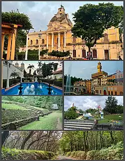 Counterclockwise from top: Palacio Departamental Retalhuleu, Retalhuleu Central Park, Xetulul, Takalik Abaj, Xocomil & rubber farms | |
 Flag | |
 Retalhuleu | |
| Country | |
| Capital | Retalhuleu |
| Municipalities | 9 |
| Government | |
| • Type | Departmental |
| Area | |
| • Department of Guatemala | 1,856 km2 (717 sq mi) |
| Population (2018)[1] | |
| • Department of Guatemala | 326,828 |
| • Density | 180/km2 (460/sq mi) |
| • Urban | 187,401 |
| • Religions | Roman Catholicism Evangelicalism Maya |
| Time zone | UTC-6 |
| Website | gobernacionretalhuleu |
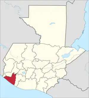
Retalhuleu (Spanish pronunciation: [retaluˈlew]) is a department located in the south-west of Guatemala, extending from the mountains to the Pacific Ocean coast. It has an area of 1856 km2. In 2018 the population of the Department of Retalhuleu was 326,828.[1] Its capital, Retalhuleu City, mixes ancient and modern architecture, and it is also known for being a commercial city.
The largest Native American group in the state is the K'iche' (Quiché) Maya people. The department contains a number of Pre-Columbian ruins, including Takalik Abaj, and it also contains numerous amusement parks, the most important and known are Xetulul and Xocomil.
Municipalities
The department is divided into nine municipalities:
Geography
Tropical savanna climates have monthly mean temperature above 18 °C (64 °F) in every month of the year and typically a pronounced dry season, with the driest month having precipitation less than 60mm (2.36 in) of precipitation. The Köppen Climate Classification subtype for this climate is "Aw". (Tropical Savanna Climate).[2]
Climate
| Climate data for Retalhuleu | |||||||||||||
|---|---|---|---|---|---|---|---|---|---|---|---|---|---|
| Month | Jan | Feb | Mar | Apr | May | Jun | Jul | Aug | Sep | Oct | Nov | Dec | Year |
| Mean daily maximum °C (°F) | 31 (87) |
31 (87) |
31 (88) |
32 (89) |
30 (86) |
30 (86) |
29 (85) |
30 (86) |
29 (85) |
29 (85) |
31 (87) |
31 (87) |
31 (87) |
| Mean daily minimum °C (°F) | 24 (75) |
24 (76) |
26 (78) |
26 (78) |
25 (77) |
25 (77) |
25 (77) |
24 (76) |
24 (75) |
24 (76) |
24 (76) |
24 (76) |
24 (76) |
| Average precipitation cm (inches) | 5.1 (2) |
2.5 (1) |
5.1 (2) |
7.6 (3) |
20 (8) |
36 (14) |
38 (15) |
36 (14) |
46 (18) |
36 (14) |
15 (6) |
5.1 (2) |
250 (99) |
| Source: Weatherbase [3] | |||||||||||||
References
- 1 2 Citypopulation.de Population of departments in Guatemala
- ↑ Climate Summary
- ↑ "Weatherbase: Historical Weather for Retalhuleu, Gtatemala". Weatherbase. 2013. Retrieved on April 24, 2013.
Flag of Guatemala | ||
14°32′07″N 91°40′42″W / 14.5353°N 91.6783°W