Rheinhessen-Pfalz
Regierungsbezirk Rheinhessen-Pfalz | |
|---|---|
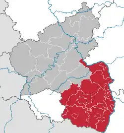 Map of Rhineland-Palatinate highlighting the former Regierungsbezirk of Rheinhessen-Pfalz | |
| Coordinates: 49°21′N 8°09′E / 49.350°N 8.150°E | |
| Country | Germany |
| State | Rhineland-Palatinate |
| Established | 1968 |
| Disestablished | 2000-01-01 |
| Region seat | Neustadt (Weinstraße) |
| Area | |
| • Total | 6,851.84 km2 (2,645.51 sq mi) |
| Population (2001) | |
| • Total | 2,011,381 |
| • Density | 290/km2 (760/sq mi) |
| GDP | |
| • Total | €90.984 billion (2021) |
Rheinhessen-Pfalz (rarely anglicized as "Rhine-Hesse-Palatinate") was one of the three Regierungsbezirke of Rhineland-Palatinate, Germany, located in the south of the state. It was created in 1968 out of Regierungsbezirke Rheinhessen and Pfalz, which had themselves been created out of the left-bank territories of Bavaria and Hesse-Darmstadt before World War II.
Since 2000, the employees and assets of the Bezirksregierungen form the Aufsichts- und Dienstleistungsdirektion Trier (Supervisory and Service Directorate Trier) and the Struktur- und Genehmigungsdirektionen (Structural and Approval Directorates) Nord in Koblenz and Süd in Neustadt (Weinstraße). These administrations execute their authority over the whole state, e.g. the ADD Trier oversees all schools.
|
Kreise
|
Kreisfreie Städte
|
References
- ↑ "EU regions by GDP, Eurostat". Retrieved 18 September 2023.
Former Regierungsbezirk in Rhineland-Palatinate (1946-2000) | |||
|---|---|---|---|
| |||