Rhine, Georgia | |
|---|---|
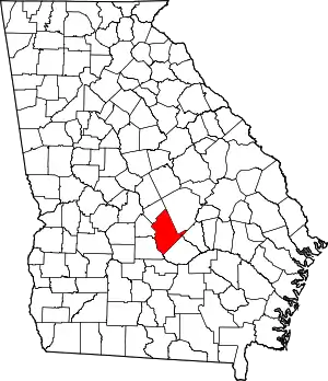
 Location in Dodge County and the state of Georgia | |
| Coordinates: 31°59′23″N 83°11′56″W / 31.98972°N 83.19889°W | |
| Country | United States |
| State | Georgia |
| County | Dodge |
| Area | |
| • Total | 3.14 sq mi (8.14 km2) |
| • Land | 3.13 sq mi (8.12 km2) |
| • Water | 0.01 sq mi (0.02 km2) |
| Elevation | 243 ft (74 m) |
| Population (2020) | |
| • Total | 295 |
| • Density | 94.13/sq mi (36.34/km2) |
| Time zone | UTC−5 (Eastern (EST)) |
| • Summer (DST) | UTC−4 (EDT) |
| ZIP Code | 31077 |
| Area code | 229 |
| FIPS code | 13-64932[2] |
| GNIS feature ID | 0321548[3] |
Rhine is a town in Dodge County, Georgia, United States. The population was 295 in 2020.
History
A post office called Rhine was established in 1890.[4] The community was named after the Rhine river, in Germany, the native land of a large share of the first settlers.[5] The Georgia General Assembly incorporated Rhine as a town in 1891.[6]
Geography
Rhine is located in southern Dodge County at 31°59′23″N 83°11′56″W / 31.98972°N 83.19889°W (31.989696, -83.198762).[7] U.S. Route 280 passes through the town, leading west 6 miles (10 km) to Abbeville and east 8 miles (13 km) to Milan. Georgia State Route 117 crosses US 280 in the center of Rhine, leading north 15 miles (24 km) to Eastman, the Dodge County seat, and southeast 19 miles (31 km) to Jacksonville, Georgia. State Route 165 diverges from SR 117 in the north part of town and leads 11 miles (18 km) northeast to Chauncey.
According to the United States Census Bureau, the town of Rhine has a total area of 3.1 square miles (8.1 km2), all land.[8]
Demographics
| Census | Pop. | Note | %± |
|---|---|---|---|
| 1900 | 191 | — | |
| 1910 | 321 | 68.1% | |
| 1920 | 396 | 23.4% | |
| 1930 | 450 | 13.6% | |
| 1940 | 463 | 2.9% | |
| 1950 | 514 | 11.0% | |
| 1960 | 485 | −5.6% | |
| 1970 | 471 | −2.9% | |
| 1980 | 590 | 25.3% | |
| 1990 | 466 | −21.0% | |
| 2000 | 422 | −9.4% | |
| 2010 | 394 | −6.6% | |
| 2020 | 295 | −25.1% | |
| U.S. Decennial Census[9] | |||
As of the census[2] of 2000, there were 422 people, 183 households, and 114 families residing in the town. By 2020, its population declined to 295.
Cultural reference
Rhine gets mentioned in Tracy Byrd's song Watermelon Crawl as the place where the annual watermelon festival takes place.[10]
References
- ↑ "2020 U.S. Gazetteer Files". United States Census Bureau. Retrieved December 18, 2021.
- 1 2 "U.S. Census website". United States Census Bureau. Retrieved January 31, 2008.
- ↑ "US Board on Geographic Names". United States Geological Survey. October 25, 2007. Retrieved January 31, 2008.
- ↑ "Post Offices". Jim Forte Postal History. Retrieved May 26, 2019.
- ↑ Krakow, Kenneth K. (1975). Georgia Place-Names: Their History and Origins (PDF). Macon, GA: Winship Press. p. 187. ISBN 0-915430-00-2.
- ↑ Acts and Resolutions of the General Assembly of the State of Georgia. Clark & Hines, State Printers. 1892. p. 727.
- ↑ "US Gazetteer files: 2010, 2000, and 1990". United States Census Bureau. February 12, 2011. Retrieved April 23, 2011.
- ↑ "Geographic Identifiers: 2010 Demographic Profile Data (G001): Rhine town, Georgia". U.S. Census Bureau, American Factfinder. Retrieved October 22, 2015.
- ↑ "Census of Population and Housing". Census.gov. Retrieved June 4, 2015.
- ↑ "Watermelon Crawl". Retrieved September 16, 2022.
