Ried im Traunkreis | |
|---|---|
 | |
 Coat of arms | |
 Ried im Traunkreis Location within Austria | |
| Coordinates: 48°0′0″N 14°0′0″E / 48.00000°N 14.00000°E | |
| Country | Austria |
| State | Upper Austria |
| District | Kirchdorf an der Krems |
| Government | |
| • Mayor | Stefan Schöfberger (SPÖ) |
| Area | |
| • Total | 31.14 km2 (12.02 sq mi) |
| Elevation | 469 m (1,539 ft) |
| Population (2018-01-01)[2] | |
| • Total | 2,739 |
| • Density | 88/km2 (230/sq mi) |
| Time zone | UTC+1 (CET) |
| • Summer (DST) | UTC+2 (CEST) |
| Postal code | 4551 |
| Area code | 07588 |
| Vehicle registration | KI |
| Website | www.ried-traunkreis.at |
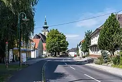
Ried im Traunkreis is a municipality in the district of Kirchdorf an der Krems in the Austrian state of Upper Austria.
Population
| Year | Pop. | ±% |
|---|---|---|
| 1870 | 1,945 | — |
| 1900 | 1,834 | −5.7% |
| 1920 | 2,010 | +9.6% |
| 1934 | 2,120 | +5.5% |
| 1961 | 2,019 | −4.8% |
| 1971 | 1,973 | −2.3% |
| 1981 | 2,106 | +6.7% |
| 1991 | 2,262 | +7.4% |
| 2001 | 2,418 | +6.9% |
| 2012 | 2,647 | +9.5% |
References
- ↑ "Dauersiedlungsraum der Gemeinden Politischen Bezirke und Bundesländer - Gebietsstand 1.1.2018". Statistics Austria. Retrieved 10 March 2019.
- ↑ "Einwohnerzahl 1.1.2018 nach Gemeinden mit Status, Gebietsstand 1.1.2018". Statistics Austria. Retrieved 9 March 2019.
Wikimedia Commons has media related to Ried im Traunkreis.
This article is issued from Wikipedia. The text is licensed under Creative Commons - Attribution - Sharealike. Additional terms may apply for the media files.