Rinkeby | |||||||||||
|---|---|---|---|---|---|---|---|---|---|---|---|
| Stockholm metro station | |||||||||||
 | |||||||||||
| General information | |||||||||||
| Location | Rinkeby | ||||||||||
| Coordinates | 59°23′17″N 17°55′43″E / 59.38806°N 17.92861°E | ||||||||||
| Elevation | 1.2 m (3.9 ft) above sea level | ||||||||||
| Owned by | Storstockholms Lokaltrafik | ||||||||||
| Tracks | 2 | ||||||||||
| Construction | |||||||||||
| Structure type | Underground | ||||||||||
| Depth | 29 m (95 ft) below ground | ||||||||||
| Accessible | Yes | ||||||||||
| Other information | |||||||||||
| Station code | RIB | ||||||||||
| History | |||||||||||
| Opened | 31 August 1975 | ||||||||||
| Passengers | |||||||||||
| 2019 | 6,250 boarding per weekday[1] | ||||||||||
| Services | |||||||||||
| |||||||||||
| Location | |||||||||||
 | |||||||||||
Rinkeby metro station is a station on the blue line of the Stockholm metro, located in the district of Rinkeby. The station was opened on 31 August 1975 as part the first stretch of the Blue Line between T-Centralen and Hjulsta. The trains were running to Hallonbergen and then to Rinkeby via a track which is currently used for the rail yard access.[2] The distance to Kungsträdgården is 12.3 km (7.6 mi).

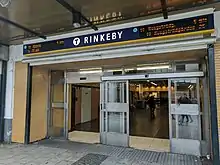
Station entrance
References
- ↑ "Fakta om SL och regionen 2019" (PDF) (in Swedish). Storstockholms Lokaltrafik. p. 51. Archived (PDF) from the original on 27 December 2020. Retrieved 31 March 2021.
- ↑ Schwandl, Robert. "Stockholm". urbanrail.
External links
This article is issued from Wikipedia. The text is licensed under Creative Commons - Attribution - Sharealike. Additional terms may apply for the media files.