| River Cong | |
|---|---|
 River Cong | |
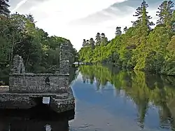
 Source of the River Cong within County Mayo | |
| Native name | Abhainn Chonga (Irish) |
| Location | |
| Country | Ireland |
| County | County Galway County Mayo |
| Province | Connacht |
| Physical characteristics | |
| Source | Village of Cong, County Mayo |
| Mouth | Flows into Lough Corrib |
• coordinates | 53°31′58″N 9°17′04″W / 53.53276°N 9.28451°W |
| Length | 1 mi (1.6 km) |
| Discharge | |
| • average | 37.6 m3/s (1,330 cu ft/s) |
The River Cong (Irish: Abhainn Chonga)[1] is a short river of moderate flow in Ireland, primarily in County Mayo but also touching County Galway.
Course
The river rises by the village of Cong, County Mayo.[2] It is formed from underground outflows from Lough Mask, a little over four miles (6.4 km) to the north, that escape through fissures in the cavernous limestone of the district, surfacing near the village.[3] The river is only about one mile (1.6 km) long but some 100 yards (91 m) wide in places. It is divided by an island at one point. It flows strongly past Ashford Castle and into Lough Corrib.[4]
Recreation
The river is popular with fishermen, having a State salmon hatchery and a strong spring salmon run. The peak of the spring run is in April and then the grilse come in May. June to early July are particularly good, and salmon are taken in lesser numbers for the rest of the season. The river also holds stocks of ferox trout (brown trout). The upper stretch has open access, while the lower part is managed by Ashford Castle, and local gillies are available.[4][5]
Cong Canal
In 1848 there was an attempt to link Lough Mask and Lough Corrib with a canal, running from Lough Mask south to Cong, and then continuing to the east of the river. The work continued during summer months for five years but was badly managed. Although all three miles of excavation and two of the three planned locks were completed, the project was stopped in 1854. Swallow holes had been found in the limestone and these were later blamed for the abandonment by Sir William Wilde in his book about Lough Corrib, although the canal is not known to have ever been watered, and competition from the railways was probably a more important reason.[6]
References
- ↑ "Príommhbhord lascaigh agus Boird lascaigh Réigiúnacha Tuarascaíl Bhliantúil Dhieridh" [Central Fisheries Board and Regional Fisheries Boards Derry Annual Report] (in Irish). Archived from the original on 24 September 2016. Retrieved 3 March 2020.
- ↑ Ordnance Survey, The Complete Road Atlas of Ireland:Published in 1997 by Ordnance Survey of Ireland. Map page 31, ISBN 1-901496-81-3
- ↑ Griffith, Richard John (1818). Geological and Mining Survey of the Connaught Coal District. Dublin: Graisberry and Campbell. p. 11.
Cong in the county of Mayo : at this place the superfluous waters of Lough Mask are conveyed in a sub terranean channel, until they burst forth near the village ... from a circular gulph, fifty yards in diameter, and rushing with astonishing velocity
- 1 2 "Lough Corrib, Lough Mask and Cong". Mayo, Ireland. Retrieved 1 March 2020.
- ↑ "Lough Corrib and its tributaries". Angling Ireland. Retrieved 1 March 2020.
- ↑ Delany, Ruth (2004). Ireland's Inland Waterways. Appletree Press. p. 173.