| Rivière des Remparts | |
|---|---|
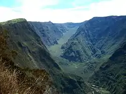 Rivière des Remparts valley upstream of Roche-Plate | |
| Location | |
| Country | France |
| Region | Réunion |
| Physical characteristics | |
| Mouth | Indian Ocean |
• coordinates | 21°23′8″S 55°37′7″E / 21.38556°S 55.61861°E |
| Length | 27.1 km (16.8 mi) |
Rivière des Remparts
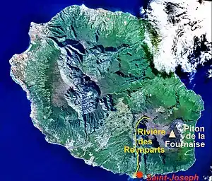
The Rivière des Remparts is a river on the Indian Ocean island of Réunion. It is 27.1 km (16.8 mi) long.[1] It flows south from the slopes of the Piton des Songes, in a deep caldera along the Piton de la Fournaise, reaching the sea at the town of Saint-Joseph. It forms part of the Rivière des Remparts – Rivière Langevin Important Bird Area.[2]
References
- ↑ Sandre. "Fiche cours d'eau - Rivière des Remparts (40000100)".
- ↑ "Rivière des Remparts – Rivière Langevin". Important Bird Areas factsheet. BirdLife International. 2014. Retrieved 2014-03-06.

Panoramic view of the Rivière des remparts
This article is issued from Wikipedia. The text is licensed under Creative Commons - Attribution - Sharealike. Additional terms may apply for the media files.