 | |
|---|---|
| Ruta nacional PY22 | |
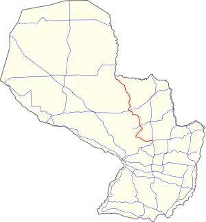 PY22 highlighted in red | |
| Route information | |
| Length | 424 km (263 mi) |
| Existed | 2019–present |
| Major junctions | |
| South end | San Estanislao |
| North end | San Lázaro |
| Location | |
| Country | Paraguay |
| Highway system | |
National Route 22[1] (officially, PY22) is a highway in Paraguay, which connects two northern departments of Paraguay, San Pedro and Concepción.
History
With the Resolution N° 1090/19,[2] it obtained its current number and elevated to National Route in 2019 by the MOPC (Ministry of Public Works and Communications).
Distances, cities and towns
The following table shows the distances traversed by PY22 in each different department, showing cities and towns that it passes by (or near).
| Km | City | Department | Junctions |
|---|---|---|---|
| 0 | San Estanislao | San Pedro | |
| 37 | Itacurubí del Rosario | San Pedro | |
| 50 | Gral. Elizardo Aquino | San Pedro | |
| 71 | Villa del Rosario | San Pedro | |
| 123 | San Pablo | San Pedro | |
| 142 | San Pedro de Ycuamandiyú | San Pedro | |
| 222 | Belén | Concepción | |
| 241 | Concepción | Concepción | |
| 263 | Loreto | Concepción | |
| 424 | San Lázaro | Concepción |
References

This article is issued from Wikipedia. The text is licensed under Creative Commons - Attribution - Sharealike. Additional terms may apply for the media files.