Rubetsu
留別村 | |
|---|---|
Village | |
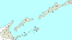
 The municipality is labeled here as number 9. | |
 Rubetsu | |
| Coordinates: 45°05′10″N 147°41′39″E / 45.0861°N 147.6941°E | |
| Country | Japan/Russia |
| Region/Federal District | Hokkaido/Far Eastern Federal District |
| Prefecture/Federal Subject | Hokkaido (Nemuro Subprefecture)/Sakhalin |
| District/District | Etorofu District/Yuzhno-Kurilsky District |
| Area | |
| • Total | 1,442.82 km2 (557.08 sq mi) |
| Population (1945) | |
| • Total | 2,814 |
| • Density | 2.0/km2 (5.1/sq mi) |
| Time zone | UTC+11 (MSK+8) |
Rubetsu (Japanese: 留別村, Rubetsu-mura, Russian: Рубэцу) is a village in Etorofu District, both of which are located in the disputed Northern Territories area of the Kuril Islands. It is currently administered by Russia as part of Yuzhno-Kurilsky District in Sakhalin Oblast, although Japan continues to claim it as part of Hokkaido Prefecture.[1]
References
- ↑ "The Northern Territories: So close, yet so far away | NHK WORLD-JAPAN News". NHK WORLD. Retrieved 2021-03-17.
This article is issued from Wikipedia. The text is licensed under Creative Commons - Attribution - Sharealike. Additional terms may apply for the media files.