| Ruisseau Saint-Joseph | |
|---|---|
 Ruisseau St-Joseph | |
 | |
| Location | |
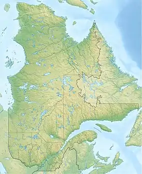
| Country | Canada |
| Province | Quebec |
| Region | Estrie |
| MRC | Le Granit Regional County Municipality |
| Physical characteristics | |
| Source | Mountain streams |
| • location | Saint-Augustin-de-Woburn |
| • coordinates | 45°27′59″N 71°00′47″W / 45.466435°N 71.012988°W |
| • elevation | 600 metres (2,000 ft) |
| Mouth | Lake Mégantic, Chaudière River |
• location | Saint-Augustin-de-Woburn |
• coordinates | 45°26′41″N 70°53′03″W / 45.44483°N 70.88428°W |
• elevation | 395 metres (1,296 ft) |
| Length | 7 kilometres (4.3 mi) |
| Basin features | |
| Progression | Lake Mégantic, Chaudière River, St. Lawrence River |
| River system | St. Lawrence River |
| Tributaries | |
| • left | (upstream) |
| • right | (upstream) |
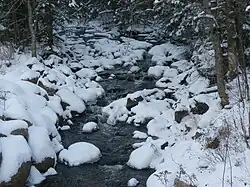
The ruisseau Saint-Joseph (in English: Saint-Joseph stream) is a tributary on the south shore of Lake Mégantic which flows into the Chaudière River; the latter flows northward to empty on the south shore of the St. Lawrence River. The stream flows in the municipality of Saint-Augustin-de-Woburn, in the Le Granit Regional County Municipality, in the administrative region of Estrie, in Quebec, in Canada.[1]
Toponymy
The toponym Ruisseau Saint-Joseph was made official on October 19, 1971, at the Commission de toponymie du Québec.[2]
See also
References
This article is issued from Wikipedia. The text is licensed under Creative Commons - Attribution - Sharealike. Additional terms may apply for the media files.