Rukla Eldership
Ruklos seniūnija | |
|---|---|
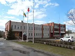
 Rukla Eldership office | |
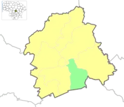
 Location of Rukla eldership | |
| Coordinates: 55°01′57″N 24°22′37″E / 55.03250°N 24.37694°E | |
| Country | |
| Ethnographic region | Aukštaitija |
| County | |
| Municipality | |
| Administrative centre | Rukla |
| Area | |
| • Total | 72.32 km2 (27.92 sq mi) |
| Population (2021) | |
| • Total | 2,210 |
| • Density | 31/km2 (79/sq mi) |
| Time zone | UTC+2 (EET) |
| • Summer (DST) | UTC+3 (EEST) |
Rukla Eldership (Lithuanian: Ruklos seniūnija) is a Lithuanian eldership, located in a southern part of Jonava District Municipality.[1] As of 2020, administrative centre and largest settlement within eldership was Rukla.[2]
Geography
- Rivers: Neris, Lankesa, Lomena;
- Forests: Gaižiūnai Forest;
- Protected areas: Lomena Landscape Sanctuary
79.03 % of Rukla eldership's whole area is covered in forests.[2]
Populated places
Following settlements are located in the Rukla Eldership (as for 2011 census):[3]
- Towns: Rukla
- Villages: Jonalaukis, Kamšalai, Konstantinava, Rukla village, Tartokas, Venecija
Transport
Demography
|
| |||||||||||||||
| Source: 1902, 1923, 1959 & 1970, 1979, 1989, 2001, 20112021 | ||||||||||||||||
Elections
2023 municipality elections
| Political party | Municipality elections | |
|---|---|---|
| Votes [4] | %[5] | |
| Social Democratic Party of Lithuania | 236 | 44.5% |
| Homeland Union | 77 | 14.5% |
| Labour Party | 49 | 9.3% |
| Lithuanian Farmers and Greens Union | 43 | 8.1% |
| Liberals' Movement | 36 | 6.8% |
| Union of Democrats "For Lithuania" | 25 | 4.7% |
| Lithuanian Regions Party | 23 | 4.3% |
| Political committee Our Jonava | 22 | 4.2% |
| Freedom Party (Lithuania) | 6 | 1.1% |
| Total registered voters: 1,770 | Turnout: 29.94% | |
References
- ↑ "Ruklos seniūnija - Seniūnijos". lrvalstybe.lt. Retrieved 26 December 2020.
- 1 2 "Ruklos seniūnija". jonava.lt. Retrieved 26 December 2020.
- ↑ "2011 census". Statistikos Departamentas (Lithuania). Retrieved August 21, 2017.
- ↑ Rezultatai 2023
- ↑ of all votes
This article is issued from Wikipedia. The text is licensed under Creative Commons - Attribution - Sharealike. Additional terms may apply for the media files.
