Ryder Lake
T'ept'óp (Halq'eméylem) "where vine maples grow" | |
|---|---|
Neighbourhood in Chilliwack | |
 Ryder Lake Location of Ryder Lake in British Columbia | |
| Coordinates: 49°06′38″N 121°52′41″W / 49.11056°N 121.87806°W | |
| City | Chilliwack |
| Province | |
| Country | |
| Settled | c. 1890 |
| Founded by | John Ferris Ryder |
| Time zone | UTC-8 (PST) |
| • Summer (DST) | UTC-7 (PDT) |
| Postal code | V2P |
| Area code | +1-604 |
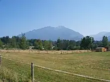
Ryder Lake is a small, sub-alpine, farming-based community located in Chilliwack, British Columbia, situated on Mount Thom to the west of Lookout Ridge.[1] A post office operated here from 1926 to 1940. Notable features in Ryder Lake include a former small elementary school and small fire hall.
The community is located east of Promontory. It is home to a great variety of wildlife and is a popular destination for hiking. The community is named after the lake of the same name.[2] The small lake is situated on private property and cannot be seen from the road because of fencing and trees.
 Gene Voight standing on Haley Road Ryder Lake Chilliwack |
 A farm in Ryder Lake |
References
External links
This article is issued from Wikipedia. The text is licensed under Creative Commons - Attribution - Sharealike. Additional terms may apply for the media files.