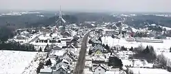
Saint-Paul-de-la-Croix | |
|---|---|
 | |
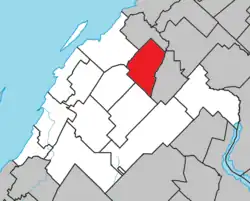 Location within Rivière-du-Loup RCM | |
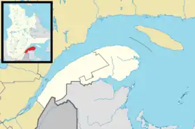 Saint-Paul-de-la-Croix Location in eastern Quebec | |
| Coordinates: 47°57′N 69°12′W / 47.950°N 69.200°W[1] | |
| Country | |
| Province | |
| Region | Bas-Saint-Laurent |
| RCM | Rivière-du-Loup |
| Constituted | January 1, 1873 |
| Government | |
| • Mayor | Philippe Dionne |
| • Federal riding | Montmagny—L'Islet—Kamouraska—Rivière-du-Loup |
| • Prov. riding | Rivière-du-Loup-Témiscouata |
| Area | |
| • Total | 85.90 km2 (33.17 sq mi) |
| • Land | 78.45 km2 (30.29 sq mi) |
| Population | |
| • Total | 309 |
| • Density | 3.9/km2 (10/sq mi) |
| • Pop 2011-2016 | |
| • Dwellings | 185 |
| Time zone | UTC−5 (EST) |
| • Summer (DST) | UTC−4 (EDT) |
| Postal code(s) | |
| Area code(s) | 418 and 581 |
| Highways | No major routes |
| Website | www |
Saint-Paul-de-la-Croix (French pronunciation: [sɛ̃ pɔl də la kʁwa]) is a municipality in Quebec, Canada, in the regional county municipality of Rivière-du-Loup Regional County Municipality and the administrative region of Bas-Saint-Laurent.
See also
References
- ↑ "Banque de noms de lieux du Québec: Reference number 57411". toponymie.gouv.qc.ca (in French). Commission de toponymie du Québec.
- 1 2 "Répertoire des municipalités: Geographic code 12035". www.mamh.gouv.qc.ca (in French). Ministère des Affaires municipales et de l'Habitation.
- 1 2 "Census Profile, 2016 Census - Saint-Paul-de-la-Croix, Paroisse (Municipalité de) [Census subdivision], Quebec and les Etchemins, Municipalité régionale de comté [Census division], Quebec". 8 February 2017.
External links
 Media related to Saint-Paul-de-la-Croix at Wikimedia Commons
Adjacent Municipal Subdivisions | ||||||||||||||||
|---|---|---|---|---|---|---|---|---|---|---|---|---|---|---|---|---|
| ||||||||||||||||
| Cities & Towns | |
|---|---|
| Municipalities | |
| Parishes | |
| |
This article is issued from Wikipedia. The text is licensed under Creative Commons - Attribution - Sharealike. Additional terms may apply for the media files.