Saint-Paul-en-Cornillon | |
|---|---|
Commune | |
 The upper village | |
.svg.png.webp) Coat of arms | |
Location of Saint-Paul-en-Cornillon | |
 Saint-Paul-en-Cornillon  Saint-Paul-en-Cornillon | |
| Coordinates: 45°23′53″N 4°14′29″E / 45.3981°N 4.2414°E | |
| Country | France |
| Region | Auvergne-Rhône-Alpes |
| Department | Loire |
| Arrondissement | Saint-Étienne |
| Canton | Firminy |
| Intercommunality | Saint-Étienne Métropole |
| Government | |
| • Mayor (2020–2026) | Sylvie Fayolle[1] |
| Area 1 | 3.72 km2 (1.44 sq mi) |
| Population | 1,345 |
| • Density | 360/km2 (940/sq mi) |
| Time zone | UTC+01:00 (CET) |
| • Summer (DST) | UTC+02:00 (CEST) |
| INSEE/Postal code | 42270 /42240 |
| Elevation | 422–713 m (1,385–2,339 ft) (avg. 430 m or 1,410 ft) |
| 1 French Land Register data, which excludes lakes, ponds, glaciers > 1 km2 (0.386 sq mi or 247 acres) and river estuaries. | |
Saint-Paul-en-Cornillon (French pronunciation: [sɛ̃ pɔl ɑ̃ kɔʁnijɔ̃]; Occitan: Sant Paul jos Cornilhon) is a commune in the Loire department in central France.[3]
Population
| Year | Pop. | ±% p.a. |
|---|---|---|
| 1968 | 598 | — |
| 1975 | 672 | +1.68% |
| 1982 | 1,045 | +6.51% |
| 1990 | 1,122 | +0.89% |
| 1999 | 1,304 | +1.68% |
| 2007 | 1,288 | −0.15% |
| 2012 | 1,339 | +0.78% |
| 2017 | 1,364 | +0.37% |
| Source: INSEE[4] | ||
Gallery
- Castle of Saint Paul en Cornillon (11th Century)
 The château
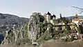 A view from the south
 A view from the east
See also
References
- ↑ "Répertoire national des élus: les maires". data.gouv.fr, Plateforme ouverte des données publiques françaises (in French). 2 December 2020.
- ↑ "Populations légales 2021". The National Institute of Statistics and Economic Studies. 28 December 2023.
- ↑ INSEE commune file
- ↑ Population en historique depuis 1968, INSEE
Wikimedia Commons has media related to Saint-Paul-en-Cornillon.
This article is issued from Wikipedia. The text is licensed under Creative Commons - Attribution - Sharealike. Additional terms may apply for the media files.