| Sall | |
|---|---|
 | |
.png.webp) Course of the Sall river (interactive map) | |
| Location | |
| Country | Germany |
| State | Baden-Württemberg |
| Physical characteristics | |
| Mouth | |
• location | Kocher |
• coordinates | 49°16′37″N 9°29′25″E / 49.2770°N 9.4903°E |
| Length | 21.3 km (13.2 mi) [1] |
| Basin features | |
| Progression | Kocher→ Neckar→ Rhine→ North Sea |
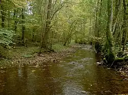
The Sall is a river of Baden-Württemberg, Germany. It flows into the Kocher near Forchtenberg.
See also
References
This article is issued from Wikipedia. The text is licensed under Creative Commons - Attribution - Sharealike. Additional terms may apply for the media files.