| Samursky National Park | |
|---|---|
| (Russian: Самурский) | |
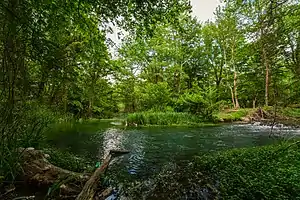
 Samur Forest, in the coastal sector of the park | |
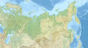
 Location of Park | |
| Location | Dagestan, Russia |
| Nearest city | Derbent |
| Coordinates | 41°52′N 48°32′E / 41.867°N 48.533°E |
| Area | 48,273 hectares (119,285 acres; 483 km2; 186 sq mi) |
| Established | December 2019 |
Samursky National Park (Russian: Национальный парк «Самурский») is located on the west coast of the Caspian Sea, at the eastern extent of the Greater Caucasus Mountains in Dagestan, Russia. It is divided into two sectors: a coastal floodplain section on the delta of the Samur River, and a mountainous sector that includes Mount Bazardüzü and the southernmost extreme point in Russia. The coastal sector is notable for supporting a temperate-subtropical liana (widespread vines) forest. The park also protects near-shore waters of the Caspian. [1] The park was officially created in 2019. [2] [3]
Topography
The Samura Delta sector (10,134 km2) occupies most of the Samur River delta in the southeast of Dagestan, on the border with Azerbaijan. It lies in Derbentsky District and Magaramkentsky District. The terrain is flat, with shifting river branches, spring streams, coastal lakes, lagoons, and beaches. This sector includes the Samur liana forest, and an offshore strip of shallow water in the Caspian Sea.[3]
The mountain sector "Shalbuzdag" (38,139 km2) lies on the northern slopes of the Caucasus Mountains, forming the Bazardyuzi-Shalbuzdag highlands. Major peaks include Mount Bazardüzü (4,466 metres (14,652 ft)), Mount Yuradag (4,466 metres (14,652 ft)), and Mount Shalbuzdag (4,142 metres (13,589 ft)). This sector is located in Dokuzparinsky District and Akhtynsky District. The southern border of this sector is also on the border between Russia and Azerbaijan.

Ecoregion and climate
The park is at the eastern extremity of the Caucasus mixed forests ecoregion. Because of differences of altitude zones, the mountainous sector rises above the forest zone.[4]
The climate of Samur delta sector is Humid continental climate, warm wet summer (Köppen climate classification (Cfa)). This climate is characterized by large seasonal temperature differentials. No month averages below 0 °C (32 °F), at least one month averages above 22 °C (72 °F), and four months average over 10 °C (50 °F). Precipitation is relatively even throughout the year.[5][6] Higher elevations in the mountainous sector are colder.
| Derbent, Dagestan | ||||||||||||||||||||||||||||||||||||||||||||||||||||||||||||
|---|---|---|---|---|---|---|---|---|---|---|---|---|---|---|---|---|---|---|---|---|---|---|---|---|---|---|---|---|---|---|---|---|---|---|---|---|---|---|---|---|---|---|---|---|---|---|---|---|---|---|---|---|---|---|---|---|---|---|---|---|
| Climate chart (explanation) | ||||||||||||||||||||||||||||||||||||||||||||||||||||||||||||
| ||||||||||||||||||||||||||||||||||||||||||||||||||||||||||||
| ||||||||||||||||||||||||||||||||||||||||||||||||||||||||||||
Plants and animals
The Samura Delta sector protects the only large liana forests in Russia. Over 500 species of vascular plants have been identified in the delta, over 1,000 species in the park overall. The dominant forest trees in the delta are English oak, common hornbeam, white poplar, alder and white willow.[7] The Samur Delta is an important wintering area for waterfowl and near-water birds. Over 300 species of birds have been recorded in the park, 130 of which are known to nest in the area. 38% of all species known in Russia have been recorded in this one park.[1][7]
The Shalbuzdag (mountainous) sector is not forested at the higher elevations, although species diversity is high overall because of the extreme altitude differences. Immediately below 3,000 meters the landscape is alpine and subalpine steppe meadows. Above 3,000 meters is scree (talus), bare rock, and glaciers.[7]
See also
References
- 1 2 "Samurskiy National Park" (in Russian). Nature Russia. Retrieved December 27, 2021.
- ↑ "On the creation of the Samursky National Park (Republic of Dagestan)". Russian Federation. Retrieved December 30, 2021.
- 1 2 "SAMURSKIY NATIONAL PARK WAS ESTABLISHED IN DAGESTAN". WWF Russia. Retrieved December 27, 2021.
- ↑ "Map of Ecoregions 2017". Resolve, using WWF data. Retrieved September 14, 2019.
- ↑ Kottek, M., J. Grieser, C. Beck, B. Rudolf, and F. Rubel, 2006. "World Map of Koppen-Geiger Climate Classification Updated" (PDF). Gebrüder Borntraeger 2006. Retrieved September 14, 2019.
{{cite web}}: CS1 maint: multiple names: authors list (link) CS1 maint: numeric names: authors list (link) - ↑ "Dataset - Koppen climate classifications". World Bank. Retrieved September 14, 2019.
- 1 2 3 "National Park Samursky" (in Russian). State Nature Reserve Dagestan. Retrieved December 30, 2021.
