San Andrés Zautla | |
|---|---|
Municipality and town | |
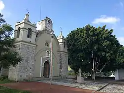
 16th century Spanish colonial church in San Andrés Zautla. | |
 San Andrés Zautla Location in Mexico | |
| Coordinates: 17°12′N 96°52′W / 17.200°N 96.867°W | |
| Country | |
| State | Oaxaca |
| Area | |
| • Total | 21.69 km2 (8.37 sq mi) |
| Population (2020) | |
| • Total | 5,326 |
| 52% male, 48% female | |
| Time zone | UTC-6 (Central Standard Time) |
| • Summer (DST) | UTC-5 (Central Daylight Time) |
San Andrés Zautla is a town and municipality in Oaxaca in south-western Mexico. The municipality covers an area of 21.69 km². It is part of the Etla District in the Valles Centrales region. As of 2005, the municipality had a total population of 5,326, of whom 281 spoke an indigenous language.[1] During the colonial period San Andrés Zautla was part of the jurisdiction of Huexolotitlan.[2] A 16th century Spanish colonial church in town is a listed Cultural Landmark, and possesses a historic pipe organ, dated 1726, now restored and playable.
References
- ↑ "San Andrés Zautla: Economía, empleo, equidad, calidad de vida, educación, salud y seguridad pública". Data México (in Spanish). Retrieved 2023-10-09.
- ↑ Peter Gerhard, Guide to the Historical Geography of New Spain (Cambridge: Cambridge University Press, 1972) p. 143-144
This article is issued from Wikipedia. The text is licensed under Creative Commons - Attribution - Sharealike. Additional terms may apply for the media files.