San Carlos | |
|---|---|
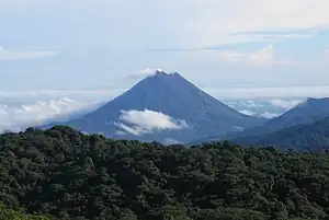 Arenal Volcano as seen from Monteverde | |
.svg.png.webp) Flag  Seal | |
San Carlos canton | |
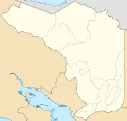 San Carlos San Carlos canton location in Alajuela Province 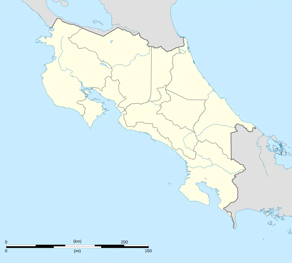 San Carlos San Carlos canton location in Costa Rica | |
| Coordinates: 10°37′13″N 84°30′43″W / 10.6203924°N 84.512°W | |
| Country | |
| Province | Alajuela |
| Creation | 26 September 1911[1] |
| Head city | Quesada |
| Districts | |
| Government | |
| • Type | Municipality |
| • Body | Municipalidad de San Carlos |
| Area | |
| • Total | 3,347.98 km2 (1,292.66 sq mi) |
| Elevation | 340 m (1,120 ft) |
| Population (2011) | |
| • Total | 163,745 |
| • Density | 49/km2 (130/sq mi) |
| Time zone | UTC−06:00 |
| Canton code | 210 |
| Website | www |
San Carlos is a canton in the Alajuela province of Costa Rica.[2][3] The capital city of the canton is Ciudad Quesada.
History
San Carlos was created on 26 September 1911 by decree 17.[1]
Geography
San Carlos has an area of 3,347.98 km²[4] and a mean elevation of 340 metres.[2]
The canton encompasses a major portion of the San Carlos Plain, a wide expanse on the Caribbean side of the Cordillera Central (Central Mountain Range). San Carlos reaches north to the border of Nicaragua, east to the province of Heredia, west to the province of Guanacaste, and south into the heights of the Cordillera.
San Carlos is noted as the home of Arenal Volcano, one of the most active volcanoes in the world. The canton's principal economic activities include the production of oranges, yuca, pineapple, sugar cane, beef and dairy products. More than 50% of the national dairy production in Costa Rica comes from San Carlos.
Districts
The canton of San Carlos is subdivided into the following districts:
Demographics
| Historical population | |||
|---|---|---|---|
| Census | Pop. | %± | |
| 1927 | 5,719 | — | |
| 1950 | 16,180 | 182.9% | |
| 1963 | 36,586 | 126.1% | |
| 1973 | 54,952 | 50.2% | |
| 1984 | 75,576 | 37.5% | |
| 2000 | 127,140 | 68.2% | |
| 2011 | 163,745 | 28.8% | |
|
Instituto Nacional de Estadística y Censos[5] |
|||
For the 2011 census, San Carlos had a population of 163,745 inhabitants.[7]
Transportation
Road transportation
The canton is covered by the following road routes:
 National Route 4
 National Route 35
 National Route 140
 National Route 141
 National Route 142
 National Route 227
 National Route 250
 National Route 702
 National Route 734
 National Route 738
 National Route 739
 National Route 744
 National Route 745
 National Route 746
 National Route 747
 National Route 748
 National Route 749
 National Route 750
 National Route 751
 National Route 752
 National Route 753
 National Route 761
 National Route 936
Education
There is a branch of the Costa Rica Institute of Technology in Santa Clara, San Carlos.
Sports
In federated soccer, San Carlos is represented by Asociación Deportiva San Carlos. This association also gives its name to numerous minor league teams that have notably excelled at the national level.
References
- 1 2 Hernández, Hermógenes (1985). Costa Rica: evolución territorial y principales censos de población 1502 - 1984 (in Spanish) (1 ed.). San José: Editorial Universidad Estatal a Distancia. pp. 164–173. ISBN 9977-64-243-5. Retrieved 5 October 2020.
- 1 2 "Declara oficial para efectos administrativos, la aprobación de la División Territorial Administrativa de la República N°41548-MGP". Sistema Costarricense de Información Jurídica (in Spanish). 19 March 2019. Retrieved 26 September 2020.
- ↑ División Territorial Administrativa de la República de Costa Rica (PDF) (in Spanish). Editorial Digital de la Imprenta Nacional. 8 March 2017. ISBN 978-9977-58-477-5.
- ↑ "Área en kilómetros cuadrados, según provincia, cantón y distrito administrativo". Instituto Nacional de Estadística y Censos (in Spanish). Retrieved 26 September 2020.
- ↑ "Instituto Nacional de Estadística y Censos" (in Spanish).
- ↑ "Sistema de Consulta de a Bases de Datos Estadísticas". Centro Centroamericano de Población (in Spanish).
- ↑ "Censo. 2011. Población total por zona y sexo, según provincia, cantón y distrito". Instituto Nacional de Estadística y Censos (in Spanish). Retrieved 26 September 2020.
External links
- SIR-ZEE Web portal for business and government in the Northern Zone