Sand Hill, Mississippi | |
|---|---|
 Sand Hill  Sand Hill | |
| Coordinates: 31°37′15″N 89°16′54″W / 31.62083°N 89.28167°W | |
| Country | United States |
| State | Mississippi |
| County | Jones |
| Elevation | 308 ft (94 m) |
| Time zone | UTC-6 (Central (CST)) |
| • Summer (DST) | UTC-5 (CDT) |
| Area code(s) | 601 & 769 |
| GNIS feature ID | 692205[1] |
Sand Hill is an unincorporated community in Jones County, Mississippi, United States. Sand Hill is located on Mississippi Highway 588 5.2 miles (8.4 km) west-northwest of Ellisville.[2]
References
- ↑ "Sand Hill". Geographic Names Information System. United States Geological Survey, United States Department of the Interior.
- ↑ Jones County, Mississippi General Highway Map (PDF) (Map). Mississippi Department of Transportation. 2010. Retrieved October 29, 2012.
Municipalities and communities of Jones County, Mississippi, United States | ||
|---|---|---|
| Cities | 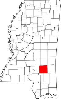 Map of Mississippi highlighting Jones County | |
| Towns | ||
| CDPs | ||
| Other communities | ||
| Indian reservation | ||
| Footnotes | ‡This populated place also has portions in an adjacent county or counties | |
This article is issued from Wikipedia. The text is licensed under Creative Commons - Attribution - Sharealike. Additional terms may apply for the media files.