Sant Mori | |
|---|---|
 Castle of Sant Mori | |
 Flag  Coat of arms | |
 Sant Mori Location in Catalonia  Sant Mori Sant Mori (Spain) | |
| Coordinates: 42°09′N 2°59′E / 42.150°N 2.983°E | |
| Country | |
| Community | |
| Province | Girona |
| Comarca | Alt Empordà |
| Government | |
| • Mayor | Modesta Cucurull Nadal (2015)[1] |
| Area | |
| • Total | 7.5 km2 (2.9 sq mi) |
| Elevation | 51 m (167 ft) |
| Population (2018)[3] | |
| • Total | 177 |
| • Density | 24/km2 (61/sq mi) |
| Demonym | santmorienc / santmorienca |
| Website | www |
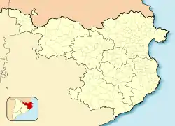
Sant Mori is a municipality in the comarca of Alt Empordà, Girona, Catalonia, Spain.
Situated on the right bank of the river Fluvià, it is limited on the north by Sant Miquel de Fluvià, on the east by Ventalló, on the south by Saus and on the west by Palau de Santa Eulàlia.
The economy is primarily based on agriculture, animal husbandry, and, more recently, tourism.
Sant Mori was a barony in the 15th century and in 1893 it became a marquisate. The regent queen Juana Enríquez and her son Ferdinand II of Aragon spent some days in the castle of Sant Mori at the height of the war against John II of Aragon. There the Parliament of the Corts Catalanes was invoked in October, 1466.
Places of interest
- Saint Mauricio's Church. 18th century
- Sant Julià's Church. Pre-Romanic style
- Sant Mori Castle, Which is more similar to a palace than to a fortification, and is built on top of older ruins. www.castellsantmori.com/
- Archeological site of an Iberian village.
References
- ↑ "Ajuntament de Sant Mori". Generalitat of Catalonia. Retrieved 2015-11-13.
- ↑ "El municipi en xifres: Sant Mori". Statistical Institute of Catalonia. Retrieved 2015-11-23.
- ↑ Municipal Register of Spain 2018. National Statistics Institute.
External links
- Government data pages (in Catalan)
This article is issued from Wikipedia. The text is licensed under Creative Commons - Attribution - Sharealike. Additional terms may apply for the media files.