Saturia
সাটুরিয়া | |
|---|---|
 Baliatali Zamindar Bari | |
.svg.png.webp) | |
| Coordinates: 23°58′30″N 90°02′30″E / 23.9750°N 90.0417°E | |
| Country | |
| Division | Dhaka |
| District | Manikganj |
| Government | |
| • Chairman | Abdul Mazid Photo |
| Area | |
| • Total | 140.12 km2 (54.10 sq mi) |
| Population (2011) | |
| • Total | 171,494 |
| • Density | 1,200/km2 (3,200/sq mi) |
| Time zone | UTC+6 (BST) |
| Website | Official Map of Saturia |
Saturia (Bengali: সাটুরিয়া) is an upazila of Manikganj District in the Division of Dhaka, Bangladesh. The administrative center is located in Saturia.
Geography
Saturia is located at 23°35′33″N 90°01′23″E / 23.5925°N 90.0231°E. It has 40,644 households and total area 140.12 km2.
Demographics
According to the 2011 Bangladesh census, Saturia Upazila had 40,644 households and a population of 171,494. 34,660 (20.21%) were under 10 years of age. Saturia had a literacy rate (age 7 and over) of 47.25%, compared to the national average of 51.8%, and a sex ratio of 1050 females per 1000 males. 8,718 (5.08%) lived in urban areas.[1][2]
As of the 1991 Bangladesh census, Saturia has a population of 140215. Males constitute 49.84% of the population, and females 50.16%. This Upazila's eighteen up population is 73439. Saturia has an average literacy rate of 22% (7+ years), and the national average of 32.4% literate.[3]
Administration
Saturia Upazila is divided into nine union parishads: Baliyati, Baried, Dargram, Dhankora, Dighulia, Fukurhati, Hargaj, Saturia, and Tilli. The union parishads are subdivided into 166 mauzas and 224 villages.[4]
The Upozila Parishad Office is at The Village name Baliati.
Education
According to Banglapedia, Baliati Iswar Chandra High School, founded in 1919, is a notable secondary school.[5]
Gallery
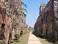 Baliati Palace
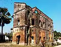 Baliati Palace
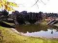 Baliati Palace - backside
See also
References
- 1 2 "Bangladesh Population and Housing Census 2011 Zila Report – Manikganj" (PDF). bbs.gov.bd. Bangladesh Bureau of Statistics.
- ↑ "Community Tables: Manikganj district" (PDF). bbs.gov.bd. 2011.
- ↑ "Population Census Wing, BBS". Archived from the original on 2005-03-27. Retrieved November 10, 2006.
- ↑ "District Statistics 2011: Manikganj" (PDF). Bangladesh Bureau of Statistics. Archived from the original (PDF) on 13 November 2014. Retrieved 14 July 2014.
- ↑ Raj, Md. Shahiduzzaman (2012). "Saturia Upazila". In Islam, Sirajul; Jamal, Ahmed A. (eds.). Banglapedia: National Encyclopedia of Bangladesh (Second ed.). Asiatic Society of Bangladesh.
| Upazila/Thana: | ||
|---|---|---|
