Schloen-Dratow | |
|---|---|
Location of Schloen-Dratow within Mecklenburgische Seenplatte district 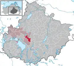 | |
 Schloen-Dratow  Schloen-Dratow | |
| Coordinates: 53°31′N 12°49′E / 53.517°N 12.817°E | |
| Country | Germany |
| State | Mecklenburg-Vorpommern |
| District | Mecklenburgische Seenplatte |
| Municipal assoc. | Seenlandschaft Waren |
| Area | |
| • Total | 36.12 km2 (13.95 sq mi) |
| Elevation | 62 m (203 ft) |
| Population (2021-12-31)[1] | |
| • Total | 872 |
| • Density | 24/km2 (63/sq mi) |
| Time zone | UTC+01:00 (CET) |
| • Summer (DST) | UTC+02:00 (CEST) |
| Postal codes | 17192, 17219 |
| Dialling codes | 039934 |
| Vehicle registration | MÜR |
Schloen-Dratow (before January 2014: Dratow-Schloen) is a municipality in the Mecklenburgische Seenplatte district, in Mecklenburg-Vorpommern, Germany. It was formed on 1 January 2012 by the merger of the former municipalities Groß Dratow and Schloen.
References
- ↑ "Bevölkerungsstand der Kreise, Ämter und Gemeinden 2021" (XLS) (in German). Statistisches Amt Mecklenburg-Vorpommern. 2022.
This article is issued from Wikipedia. The text is licensed under Creative Commons - Attribution - Sharealike. Additional terms may apply for the media files.