Schottwien | |
|---|---|
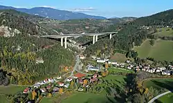 Southwest view of Schottwien | |
 Coat of arms | |
 Schottwien Location within Austria | |
| Coordinates: 47°38′N 15°52′E / 47.633°N 15.867°E | |
| Country | Austria |
| State | Lower Austria |
| District | Neunkirchen |
| Government | |
| • Mayor | Wolfgang Ruzicka |
| Area | |
| • Total | 12.52 km2 (4.83 sq mi) |
| Elevation | 569 m (1,867 ft) |
| Population (2018-01-01)[2] | |
| • Total | 660 |
| • Density | 53/km2 (140/sq mi) |
| Time zone | UTC+1 (CET) |
| • Summer (DST) | UTC+2 (CEST) |
| Postal code | 2641 |
| Area code | 02663 |
Schottwien is a town in the district of Neunkirchen in the Austrian state of Lower Austria.
Population
| Year | Pop. | ±% |
|---|---|---|
| 1869 | 838 | — |
| 1880 | 935 | +11.6% |
| 1890 | 1,104 | +18.1% |
| 1900 | 1,166 | +5.6% |
| 1910 | 1,158 | −0.7% |
| 1923 | 1,127 | −2.7% |
| 1934 | 1,137 | +0.9% |
| 1939 | 1,009 | −11.3% |
| 1951 | 921 | −8.7% |
| 1961 | 860 | −6.6% |
| 1971 | 895 | +4.1% |
| 1981 | 744 | −16.9% |
| 1991 | 685 | −7.9% |
| 2001 | 714 | +4.2% |
| 2011 | 714 | +0.0% |
References
- ↑ "Dauersiedlungsraum der Gemeinden Politischen Bezirke und Bundesländer - Gebietsstand 1.1.2018". Statistics Austria. Retrieved 10 March 2019.
- ↑ "Einwohnerzahl 1.1.2018 nach Gemeinden mit Status, Gebietsstand 1.1.2018". Statistics Austria. Retrieved 9 March 2019.
This article is issued from Wikipedia. The text is licensed under Creative Commons - Attribution - Sharealike. Additional terms may apply for the media files.