Schrems bei Frohnleiten | |
|---|---|
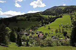 View of Schrems | |
 Coat of arms | |
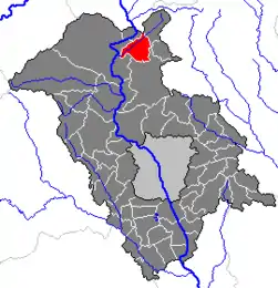 Location within Graz-Umgebung district | |
 Schrems bei Frohnleiten Location within Austria | |
| Coordinates: 47°16′46″N 15°21′51″E / 47.27944°N 15.36417°E | |
| Country | Austria |
| State | Styria |
| District | Graz-Umgebung |
| Government | |
| • Mayor | Peter Schlegl (SPÖ) |
| Area | |
| • Total | 19.25 km2 (7.43 sq mi) |
| Elevation | 493 m (1,617 ft) |
| Population (1 January 2016)[1] | |
| • Total | 602 |
| • Density | 31/km2 (81/sq mi) |
| Time zone | UTC+1 (CET) |
| • Summer (DST) | UTC+2 (CEST) |
| Postal code | 8130 |
| Area code | 03126 |
| Vehicle registration | GU |
| Website | www.schrems-frohnleiten. steiermark.at |
Schrems bei Frohnleiten is a former municipality in the district of Graz-Umgebung in the Austrian state of Styria. Since the 2015 Styria municipal structural reform, it is part of the municipality Frohnleiten.[2]
Population
| Year | Pop. | ±% |
|---|---|---|
| 1869 | 541 | — |
| 1880 | 592 | +9.4% |
| 1890 | 620 | +4.7% |
| 1900 | 571 | −7.9% |
| 1910 | 590 | +3.3% |
| 1923 | 632 | +7.1% |
| 1934 | 735 | +16.3% |
| 1939 | 684 | −6.9% |
| 1951 | 688 | +0.6% |
| 1961 | 722 | +4.9% |
| 1971 | 614 | −15.0% |
| 1981 | 575 | −6.4% |
| 1991 | 499 | −13.2% |
| 2001 | 553 | +10.8% |
| 2011 | 584 | +5.6% |
References
This article is issued from Wikipedia. The text is licensed under Creative Commons - Attribution - Sharealike. Additional terms may apply for the media files.