Selo pri Robu | |
|---|---|
 | |
 Selo pri Robu Location in Slovenia | |
| Coordinates: 45°49′49.63″N 14°32′20.15″E / 45.8304528°N 14.5389306°E | |
| Country | |
| Traditional region | Lower Carniola |
| Statistical region | Central Slovenia |
| Municipality | Velike Lašče |
| Area | |
| • Total | 4.99 km2 (1.93 sq mi) |
| Elevation | 819 m (2,687 ft) |
| Population (2002) | |
| • Total | 41 |
| [1] | |
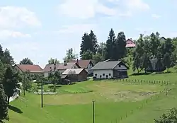
Selo pri Robu (pronounced [ˈsɛːlɔ pɾi ˈɾoːbu]) is a settlement on the Rute Plateau (Slovene: Rutarska planota) in the hills southwest of Rob in the Municipality of Velike Lašče in central Slovenia. The municipality is part of the traditional region of Lower Carniola and is now included in the Central Slovenia Statistical Region.[2]
Name
The name of the settlement was changed from Selo to Selo pri Robu in 1953.[3]
History

The area of Selo pri Robu was already settled in antiquity. A Roman road connecting Emona and the Lož Valley (Slovene: Loška dolina) ran past the village. In late antiquity it was protected by a 328 m defensive wall with towers. The village was heavily affected by the Second World War. On 24 July 1942, Italian forces burned the mill and sawmill on Iška Creek in the hamlet of Predgozd, and two days later, three villagers were shot at Big Peak (Veliki Vrh, 812 m) on the Bloke Plateau south of the village. The Krašovec family was murdered by Italian forces on 12 September that year. In 1943, three houses in the village were burned on 31 January, and additional houses on 4 August.[4]
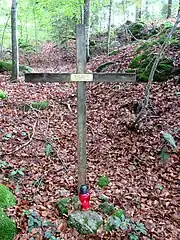
Selo pri Robu is the site of a grave from the Second World War inventoried by the Commission on Concealed Mass Graves in Slovenia. The Janez Klančar Grave (Slovene: grob Janeza Klančarja) is located in the woods northwest of the village, next to the Romani Mass Grave in neighboring Bukovec, and is marked with a cross.[5][6] Klančar was a farmer from Mohorje and was abducted from his home by the Slovene Partisans on September 27, 1942.[7][8][9]
Cultural heritage
There is a small 18th-century chapel-shrine at the crossroads at the centre of the settlement.[10]
References
- ↑ Statistical Office of the Republic of Slovenia
- ↑ Velike Lašče municipal site
- ↑ Spremembe naselij 1948–95. 1996. Database. Ljubljana: Geografski inštitut ZRC SAZU, DZS.
- ↑ Savnik, Roman, ed. 1971. Krajevni leksikon Slovenije, vol. 2. Ljubljana: Državna založba Slovenije. pp. 431–432.
- ↑ Ferenc, Mitja (December 2009). "Grob Janeza Klančarja". Geopedia (in Slovenian). Ljubljana: Služba za vojna grobišča, Ministrstvo za delo, družino in socialne zadeve. Retrieved November 26, 2023.
- ↑ "Odlok o občinskem prostorskem načrtu Občine Velike Lašče" (PDF). Uradno glasilo Občine Velike Lašče. 7: 17. 2013. Retrieved April 7, 2020.
- ↑ "Uničevalci svojega naroda". Domoljub. No. 14. April 7, 1943. p. 3. Retrieved October 23, 2023.
- ↑ Škerbec, Matija (1954). Krivda rdeče fronte, vol. 1. Cleveland. p. 76.
{{cite book}}: CS1 maint: location missing publisher (link) - ↑ "Žrtve II. sv: Janez Klančar". Zgodovina Slovenije - SIstory. Ljubljana: Inštitut za novejšo zgodovino. Retrieved October 23, 2023.
- ↑ Slovenian Ministry of Culture register of national heritage reference number ešd 26298
External links
 Media related to Selo pri Robu at Wikimedia Commons
- Selo pri Robu on Geopedia
