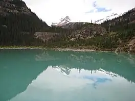
| Sherbrooke Lake | |
|---|---|
 Sherbrooke Lake | |
 Sherbrooke Lake | |
| Location | Yoho National Park |
| Coordinates | 51°27′30″N 116°23′16″W / 51.458333°N 116.387778°W |
| Primary inflows | Sherbrooke Creek |
| Primary outflows | Sherbrooke Creek |
| Basin countries | Canada |
| Settlements | None |
Sherbrooke Lake is a lake in Yoho National Park, British Columbia, Canada.[1] The lake is bounded on the west by Mount Ogden 2,695 m (8,842 ft), Mount Niles 2,972 m (9,751 ft) to the north, and Paget Peak on the east side. The lake can be reached by following a three km hiking trail that begins from the Trans-Canada Highway across from Wapta Lake.[2]
Sherbrooke Lake also serves as an access point for mountaineering access to the Waputik Icefield and the Scott Duncan Hut.
See also
References
- ↑ "Sherbrooke Lake". BC Geographical Names. Retrieved 2021-11-05.
- ↑ "Day Hikes in Yoho National Park". Parks Canada. Retrieved 2021-11-05.
External links
This article is issued from Wikipedia. The text is licensed under Creative Commons - Attribution - Sharealike. Additional terms may apply for the media files.